
From collection Jesup Library Maine Vertical File

Page 1
Page 2
Page 3
Page 4
Page 5
Page 6
Page 7
Page 8
Page 9
Page 10
Page 11
Page 12
Page 13

Page 14
Page 15
Page 16
Page 17
Page 18
Page 19
Page 20
Page 21
Page 22
Page 23
Page 24
Page 25
Page 26
Page 27
Page 28
Page 29
Page 30
Page 31
Page 32
Page 33
Page 34
Page 35
Page 36
Page 37
Page 38
Page 39
Page 40
Page 41
Page 42
Page 43
Page 44
Page 45
Page 46
Search
results in pages
Land Protection Plan: Acadia National Park
Land Protection Plan
Acadia
National
Park
LAND PROTECTION PLAN
Acadia National Park
MARCH 1988
Recommended by:
3/25/88
Jack Hauptman, Superintendent
Date
Approved by:
4/2/88
Herbert S. Cables, Jr., , Regional Director
Date
North Atlantic Region
Acadia National Park
National Park Service
U.S. Department of the Interior
P.O. Box 177
Bar Harbor, Maine
04609
207-288-3338
TABLE OF CONTENTS
Page
SUMMARY
ii
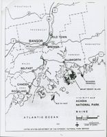
LOCATION MAP
iii
I.
INTRODUCTION
1
II.
PURPOSE OF THE PARK AND RESOURCES TO BE PROTECTED
2
Purposes
2
Significance of the Park
2
Special Legislative, Administrative, or Congressional
Directives
2
Resource Management
3
III. LAND OWNERSHIP AND USES
5
General Description
5
External Influences
5
Protection Alternatives
6
Other Considerations
6
IV.
RECOMMENDATIONS
7
Protection Methods
7
Priorities for Protection
8
Compatibility Guidelines
24
Assessment of Impacts
27
APPENDICES
Definitions
A
Land Protection Overview
B
Public Law 99-420
C
Boundary Legislation Maps
D
Letters of Intent
E
SUMMARY
CURRENT OWNERSHIP (Acres)
Tracts
Acres
Federal - National Park Service
35,057.86
Other Federal Agencies
(U.S. Coast Guard)
27.65
State
8.50
Local Governments
101.25
Private
1,925.62
37,120.31
Conservation Easements
5,854.42
TOTAL ACADIA NP ACREAGE
42,975.30
TRACTS TO BE ACQUIRED
182
2,063.02
TRACTS TO BE DELETED
23
722.91
PARK BOUNDARY
The Park boundary as specified in Public Law 99-420 is depicted on the
map entitled "Acadia National Park Boundary Map," numbered 123-80,011,
dated May 1986. The Act established a permanent Park boundary and
authorized acquisition of land within the boundaries and conservation
easements on parcels of land adjacent to the Park on Schoodic Peninsula,
the islands of Hancock County, and the islands of Knox County east and
south of the Penobscot Ship Channel, except such islands as lie within
the Town of Isle au Haut, Knox County.
[The boundary for that portion of Acadia National Park that lies within
the Town of Isle au Haut is depicted on the map entitled "Boundary Map,
Acadia National Park, Town of Isle au Haut, Maine," numbered 123-80003,
and dated October 1981. ]
FUNDING STATUS
Authorized acquisition ceiling
$9,100.000
Appropriated to date
3,500,000
Obligated to date
0
Unobligated balance
3,500,000
ii
6
PISCATAQUIS
2
6
95
PENOBSCOT
9
OLD TOWN
2
BANGOR
9
WASHINGTON
95
BREWER
202
HANCOCK
1
ELLSWORTH
WALDO
3
BELFAST
3
SCHOODIC
CAMDEN
PENNSULA
KNOX
MOUNT DESERT ISLAND
ROCKLAND
VIGINITY MAP
ACADIA
ISLE AU HAUT
NATIONAL PARK
MAINE
ATLANTIC OCEAN
D
5
10
20
SCALE MILES
H
123
40005E
iii
JUNE 87 NARO
UNITED STATES DEPARTMENT OF THE INTERIOR 1 NATIONAL PARK SERVICE
I. INTRODUCTION
This plan has been prepared in response to the 1982 Department of the
Interior policy requiring each park with non-Federal land within the
authorized boundary to prepare a Land Protection Plan. It has been
prepared in response to Public Law 99-420 enacted on September 25,
1986, which established a permanent Park boundary and required guidelines
to be prepared outlining the conditions that determine when property
is being developed or proposed to be developed in a manner which is
detrimental to the scenic, historical, cultural or other values for
which the Park was established. In addition, P.L. 99-420 authorized the
Park Service to acquire conservation easements for lands outside the
boundary which have important natural, cultural, and scenic resources.
The major issues to be addressed by this Land Protection Plan include:
1. Criteria the National Park Service will use to insure that
non-Federal property within the authorized boundary is used in a manner
which protects the scenic, historical, cultural, natural and other
values for which the park was established.
2.
Criteria to determine when reconstruction or expansion of a private
or commercial building is compatible with Park values.
3. Priorities for acquiring lands to assure that available funds are
used to protect the most important resources.
4. Criteria the National Park Service will use to guide decisions about
acquisition of conservation easements outside the boundary within the
area known as "Schooner Head," lands adjacent to the Park on Schoodic
Peninsula, the islands of Hancock County, and the islands of Knox County
east and south of the Penobscot Ship Channel, except such islands as
lie within the Town of Isle au Haut, Knox County.
NOTE: This plan is not an offer to purchase or exchange interests in
land. It does not diminish or expand the rights of landowners to use
their property in accordance with any applicable laws, regulations,
or restrictions of record.
1
II. PURPOSE OF THE PARK AND RESOURCES TO BE PROTECTED
A. Purposes
Acadia National Park was created for "the topographic configuration, the
geology, the fauna, and the flora
that are of great scientific
interest. " Congress stated that the Park "be a national park and
dedicated as a public park for the benefit and enjoyment of the
people
Situated off the coast of Maine in the heart of the old
region of Acadia, Acadia National Park conserves mountains and rugged
islands that are unequaled along the Atlantic coast.
B. Significance of the Park
Set along the Maine coast, north of the heavily populated eastern
seaboard, Acadia National Park is a unique natural reserve as well as a
heavily used recreational resource with a wide range of physiographic
and biologic features.
The northern coniferous and temperate deciduous forests meet and overlap,
bringing together nearly 1,500 species of trees, shrubs, and herbaceous
plant life. Approximately 50 species of mamimals and 327 species of
birds, as well as numerous amphibians and reptiles, have been reported
here. Acadia National Park conserves panoramas and scenic vistas of
mountains, rocky coasts, islands, and the ocean. Most of the Park's 50
miles of rocky shoreline is characterized by cliffs, boulder beaches,
and tidal pools. Cultural resources range from structures echoing
the region's historic traditions to a 43-mile system of carriage roads
and bridges built from the mid-1920's to early 1930's.
These natural, cultural, and scenic resources of Acadia National Park
provide present and future generations with outstanding values of the
Mount Desert archipelago.
C. Special Legislative, Administrative or Congressional Directives
Acadia National Park originated from the Sieur de Monts National
Monument, which was established on July 8, 1916, by Presidential
Proclamation Number 1339 under authority of the Act of June 8, 1906,
"An Act for the Preservation of American Antiquities." Sieur de Monts
National Monument was approximately 5,000 acres in size and included
the summit of Cadillac Mountain, then called Green Mountain.
In 1919 legislation was enacted changing the name from Sieur de Monts
National Monument to Lafayette National Park and again in 1929 to change
the name to Acadia National Park. The 1929 Act authorized the Secretary
of Interior to accept property by donation on Mount Desert Island and
throughout the archipelago of Acadia within Hancock County and such
islands in Knox County that lie east and south of the main ship channel
through Penobscot Bay. With the exception of the Schoodic Peninsula
2
on the mainland in Hancock County, the National Park Service directed its
management and land acquisition efforts towards the islands within this
1929 Park boundary.
From 1929 to 1985, fourteen additional pieces of legislation were enacted
for purposes of adjusting the Park boundary. With additional lands
acquired through either donation, transfer from another Federal agency,
or exchange, by 1985 the Park expanded to approximately 41,000 acres
including nearly 6,000 acres protected by conservation easements.
On September 25, 1986, P.L. 99-420 was enacted establishing a permanent
Park boundary. This legislation is intended to limit future development
within the Park boundary and authorizes the Secretary of the Interior to
acquire lands and establish an advisory commission. The Secretary is
authorized to acquire conservation easements outside the Park boundary
according to specific criteria. A land acquisition ceiling of $9.1
million was established. A copy of P.L. 99-420 is in the appendix.
Since the passage of P.L. 99-420, Congress has appropriated $3.5 million
for land acquisition.
D.
Resource Management
Land classification and resource management zones published in the
1978 Statement for Management consist of:
1. Natural Environment Zone - This zone comprises the major portion
of lands within the Park. Approximately 28,800 acres fall under this
classification. This zone includes the predominantly forested lands
of the Park except for areas within the Outstanding Natural Zone.
Development and use is limited to a network of 120 miles of trails
which enable visitors to experience a variety of natural habitats and
environs.
2.
Outstanding Natural Zone - These langs, approximately 4,000 acres,
contain the areas of scenic splendor, natural wonder, or scientific
importance and are the heart of the Park. These lands receive the
highest order of attention to monitor different levels of use and
activities. Areas classified in this category on Mount Desert Island
include Cadillac Mountain, Acadia Mountain and the adjacent shoreline
of Somes Sound, the Big Heath area in Southwest Harbor, the Fresh Meadow
of Northeast Creek, all of the shoreline along Ocean Drive and in the
Seawall and Bass Harbor areas, and the Porcupine Islands located in
Frenchman's Bay. At Schoodic, Schoodic Island, Rolling Island, Little
Moose Island, Pond Island, and all of the Park-owned shoreline fall
into this zone. Development and use in this zone is limited to trails,
off-trail hiking or climbing, and interpretive activities.
3. Historic and Cultural Zones - This category includes areas and
structures of historical or cultural significance. Areas falling within
this zone, approximately 500 acres, include all of the carriage roads,
3
the Carroll Farm, Islesford Museum, Baker Island, Egg Rock Island,
Bear Island and Bass Harbor Light.
4. Development Zone - Approximately 1,100 acres are reserved for the
visitor center, administrative and maintenance facilities, campgrounds,
picnic areas, motor roads, parking areas, developed beach areas and
concession operated facilities.
4
III. LAND OWNERSHIP AND USES
A. General Description
The area within the permanent Park boundary as established in P.L. 99-420
is 42,252.62 acres within the towns of Bar Harbor, Mount Desert,
Southwest Harbor, Tremont, Gouldsboro, Winter Harbor, Trenton, Cranberry
Isles, Swans Island and Frenchboro. The Park owns 35,057.86 acres as
well as 117 conservation easements covering 5,854.42 acres; 2,063.02
acres are in private, other Federal, State or town ownership. The
boundary legislation authorized 722.91 acres to be deleted from the
Park.
1. Private Property - The private property located within the Park
consists of:
a) Undeveloped Property - One hundred twenty-three tracts of
undeveloped private land consisting of 1,534.11 acres are within
the Park. These tracts vary in size from 123 acres to .70 acre.
The characteristics of these tracts vary from scenic coastal areas
to forested interior areas, uplands and wetlands, and areas. along
roads or accessible only by foot.
b) Developed Property - Thirty-eight developed tracts consisting
of 370.11 acres of residential tracts and 21.4 acres of commercial
tracts are within the Park. The residential tracts vary in size
from 62 acres to .07 acre. The two commercial tracts are 9 and
12.4 acres.
2. Public Lands - The public lands located within the Park include:
a)
Other Federal Lands - The U.S. Coast Guard has jurisdiction
over four tracts of land which include three operating lighthouses
located on Egg Rock Island - 1AWH; Baker Island - 3ACI; and Bass
Harbor Head - 1AT. The remaining tract includes a non-operating
lighthouse on Bear Island - 6ACI. These tracts total 27.65 acres
and vary in size from 11.75 to less than one acre.
b) State Lands - State-owned lands include three tracts: Green
Islands - ISI, 2SI; and Drum Island - 3SI; and consist of 8.5 acres.
c) Town Lands - Eight tracts owned by the local towns and totalling
101.25 acres are within the Park. Three tracts, 70ABH, 28AT and
28ASW, are existing town roads. These tracts vary in size from
.50 acre to 40 acres.
B. External Influences
Both seasonal and year-round populations of Mount Desert Island are
increasing. From 1970 to 1980, year-round population on Mount Desert
5
Island increased by 15% This population increase, which was shared
by few other areas along the Maine Seaboard, triggered the construction
of new homes throughout Mount Desert Island.
Between 1983 and 1986, the Town of Bar Harbor experienced a 50% increase
in overnight units from 1,500 to 2,256 units. Throughout Mount Desert
Island many residences are converting to bed and breakfast
establishments.
All of the towns on Mount Desert Island have some form of land use
zoning. The Towns of Bar Harbor and Mount Desert have detailed and
well-tested ordinances. In all four towns on the Island, land abutting
the Park is sought for development.
C. Protection Alternatives
Several alternate methods of protecting land are usually considered in
National Park Service plans. These include local zoning, environmental
regulation, easements, and cooperative agreements. Some of these methods
will be useful for protecting land outside of the boundary. However, the
long legislative history of P.L. 99-420 only considered acquisition of
fee title as the appropriate method for protecting land within the Park
boundary. Alternatives to acquisition of fee title may be useful to
provide interim protection, but this plan will detail different methods
of acquiring the necessary interests rather than alternative protection
strategies.
D. Other Considerations
The Park boundary established by Congress was the result of negotiations
seeking an acceptable compromise since the early 1960's. The tracts
within the boundary have been consistently identified throughout these
negotiations for acquisition by the National Park Service. During
this period most landowners did not develop their tracts, despite intense
development pressures throughout Mount Desert Island. However, several
significant tracts identified for Park acquisition were developed and
subsequently were excluded from the boundary.
6
IV. RECOMMENDATIONS
A.
Protection Methods
1. Lands Inside the Park Boundary - At Acadia National Park lands
inside the Park boundary have been identified, analyzed, and justified
for inclusion within the Park since the early 1960's. Due to strong
public and private interest over the years, only lands of outstanding
significance were included in the Park. In order to provide for long
term protection of these specific lands, acquisition of fee simple title
estates by purchase, donation, exchange, or condemnation (subject to the
limits established in the authorizing legislation) eventually will be
required. The National Park Service recognizes that acquisition may
take decades or even generations, but this level of land protection is
necessary and appropriate to protect natural and cultural resources and
provide opportunities for public use.
The preferred method of fee acquisition will be exchange, or donation
from governmental agencies, non-profits and those willing to donate.
The National Park Service will seek to acquire by purchase all other
lands within the legislated boundary, subject to availability of funds.
The decision of donation or purchase lies solely with the landowner.
The National Park Service will purchase lands only on a willing seller
basis unless proposed development is inconsistent with the Compatibility
Guidelines (refer to page 24).
2. Lands Outside the Park Boundary - When establishing a permanent
Park boundary, Congress recognized that important natural, cultural,
and scenic resources throughout the archipelago could receive additional
protection through the use of conservation easements, and authorized
the Secretary to acquire conservation easements "on parcels of land
adjacent to the Park on Schoodic Peninsula, the islands of Hancock
County, and the islands of Knox County east and south of the Penobscot
Ship Channel, except such islands as lie within the Town of Isle au
Haut, Knox County." Lands outside the Park boundary will be protected
by the donation or purchase of conservation easements from willing
grantors or sellers. However, donation of easements on lands outside
the boundary will continue to be the preferred method of conservation
easement acquisition. (See an additional provision of lands on Schooner
Head under Compatibility Guidelines. )
Conservation easements acquired or accepted by the National Park Service
which are outside the Park boundary must possess one or more of the
following characteristics:
1. important scenic, ecological, historic, archeological, or
cultural resources;
2.
shorefront property; or
3.
largely undeveloped entire islands.
7
No easements will be acquired by the National Park Service without
first consulting with, and providing written notification to, the town
in which the land is located and the Acadia National Park ;Advisory
Commission. In providing such notification, the National Park Service
shall indicate the manner and degree to which the easement meets the
criteria set forth above and its relationship to other easement parcels
outside the Park boundary.
As authorized in P.L. 99-420, conservation leasements on lands upon
Schooner Head shall be acquired without the consent of the owner only if
future development is inconsistent with the Compatibility Guidelines
(see page 24).
In administration of Acadia's conservation easement program, the National
Park Service will continue to recognize and accept conservation easements
negotiated with assistance from organizations such as the Maine Coast
Heritage Trust, the National Park Foundation, and other interested
conservation organizations and landowners using the above defined
criteria to assess easement compatibility.
3. Notification - The National Park Service shall consult with the
towns and the Acadia National Park Advisory Commission on matters
relating to:
-the acquisition of lands and interests in lands, including
conservation easements on lands outside the Park boundary;
-the termination of rights of use and occupancy.
B. Priorities for Protection
1. Lands Inside the Park Boundary - During the years of negotiations
to establish a permanent Park boundary, lands throughout the Acadia
archipelago were evaluated for natural, cultural and scenic resource
values and for administrative requirements. The results of these
evaluations identified significant resource lands to be added and lands
to be deleted from Acadia National Park.
Responding to the House Committee Report that encourages the acquisition
of land from willing sellers in an expeditious manner, and realizing
that land acquisition funds may be limited, this Plan will apply
resources value criteria along with existing and potential development
to establish land protection priorities.
The following characteristics were used to evaluate tracts within the
Park boundary to determine relative resource significance.
-important habitat, especially for rare and endangered species
-important cultural resources
-wetlands and shorelines of high ecological value
-scenic quality
-potential to impact adjacent Park lands
8
-public and private access and use conflicts
-resources management, enforcement and administrative requirements
The following table is an analysis of the tracts identified in
P.L. 99-420 as they relate to these characteristics.
9
EVALUATION OF TRACTS WITHIN THE BOUNDARY
Important
wetlands or
Landscapes
Potential
Private vs.
Res.Mgm+.
Need for
Habitat,
shoreline
hillsides or
to develop
Public
Admin. and
site ro
especially
with high
shoreline
landlocked
conflict
Low Enforce
clamation/
for rare/
ecological
with high
tracts
for use of
ment needs
rehabilita
endangered
value
sconic
shoreline,
to straighten
+1on
species
value
trails,
Irregular
or resources
roads or
boundaries
of significant
other access
cultural value
BAR HARBOR
IABH
o
2ABH-29ABH
o
o
o
30ABH (D)
31ABH (D)
33ABH
o
o
34ABH
o
35ABH
o
o
o
36ABH
#
o
o
o
37ABH
.
o
o
o
38ABH
e
o
o
o
39ABH
o
o
o
40ABH
41A-ABH
o
418-ABH (D)
O
42ABH (D)
o
43ABH (D)
#
44ABH
o
45A-ABH
o
458-ABH
o
45C-ABH
o
450-ABH
o
45E-ABH (D)
o
46A-ABH (D)
o
468-ABH
o
46C-ABH
e
o
47ABH
o
47A-ABH
e
o
48ABH
o
49ABH
e
o
55A-ABH
e
o
56ABH
e
o
57ABH
e
o
58ABH
n
o
o
62ABH
o
O
64ABH
o
65ABH
o
66ABH
o
67ABH
o
68ABH
e
70ABH
o
O
71ABH
(D) Donotes developed tract IS of Nove-!
- 10 -
Denotes Major Tract Characteristi:
o
Denotes Minor Tract Charactertistic
EVALUATION OF TRACTS WITHIN THE BOONCARI conco.
Important
Wetlands or
Landscapes
Potential
Private vs.
Res.Mgmt.
HOO
for
Habitat,
shoreline
hillsides or
to develop
Public
Admin. and
site
especially
with high
shoreline
landlocked
conflict
Low Enforce
clamation.
for rare/
ecological
with high
iracts
for use of
ment needs
renabillt
endangered
value
sconic
shoreline,
to straighten
tion
species
value
trails,
Irregular
or resources
roads or
boundaries
of significant
other access
cultural value
MOUNT DESERT
IAMD
o
IA-AMD
4AMD
o
s
5AMD
6AMD
e
7AMD (D)
#
9AMD
o
o
10AMD (D)
.
o
11AMD (D)
o
o
e
12AMD (D)
o
o
n
13AMD (D)
o
n
14AMD (D)
o
e
15AMD (D)
o
e
16AMD (D)
o
e
17AMD (D)
o
e
18AMD (D)
o
19AMD
n
o
a
20A-AMD (D)
o
q
20B-AND 10
#
o
n
21AMD
o
o
21A-AMD (D)
e
o
218-AMD (D)
a
O
n
22AMD (D)
o
23AMD (D)
o
o
e
24AMD
o
o
25AMD
e
o
o
e
26AMD
o
e
o
26A-AMD
27AMD
o
28AMD
o
28A-AMD
o
29AMD (D)
o
30AMD
o
o
31AMD (D)
o
o
32AMD
o
SOUTHWEST
HARBOR
IASW
o
o
o
s
2ASW
o
o
o
3ASW (D)
o
4ASW
o
s
5ASW
w
6ASW
(D) Donotes developed tract as of November
Denotes Major Tract Characteristic
- 11 -
o
Donotes Minor Tract Charactoriistic
EVALUATION OF TRACTS WITHIN THE BOUNDARY
contd
Important
wetlands or
Landscapes
Potential
Private vs.
Res.Mgmt.
Need for
Habitat,
shoreline
Allisides or
to develop
Public
Admin. and
site
especially
with high
shoreilne
landlocked
conflict
Law Enforce
clamation/
for rare/
ecological
with high
tracts
for use of
ment needs
rehebility
endangered
value
sconic
shoreline,
to straighten
tion
species
value
trails,
Irregular
or resources
roads or
boundaries
of significant
other access
cultural value
SOUTHWEST
HARBOR
7ASW
o
O
o
o
8ASW
e
O
9ASW
o
O
o
IOASW
e
O
o
O
11ASW (D)
e
12ASW
o
O
o
o
13ASW
n
O
o
15ASW (D)
e
o
16ASW
18ASW
e
o
o
19ASW
o
o
20ASW
e
o
21ASW
e
o
22ASW
o
23ASW
e
o
24ASW (D)
e
O
o
25ASW (D)
n
o
o
26ASW (D)
o
27ASW
#
O
28ASW
e
29ASW
e
o
TREMONT
IAT (D)
e
o
IA-AT
n
o
o
o
o
2AT
e
o
o
o
o
3AT
e
o
o
o
o
4AT
e
o
o
o
5AT
e
o
o
o
6AT
n
o
o
o
7AT
e
o
BAT
n
o
9AT
n
o
10AT
o
o
11AT
e
o
e
12AT
13AT
.
.
14AT
15AT (D)
s
o
o
16AT
e
o
o
17AT (D)
e
o
o
18AT
o
o
188-AT
o
(D) Donotes developed tract 83 of November 1. 1.66
- 12 -
Denotes major Tract Characteristic
o
Donotes Minor Charactertistic
EVALUATION OF TRACTS WITHIN THE BOUNDARY contd.
Important
wetlands or
Landscapes
Potential
Private vs.
Res.Mgmt.
Need
for
Haoltat,
shoreline
allisides or
to devoloo
Public
Admin. and
site
especially
with high
shoreline
landlocked
conflict
Low Enforce-
clamation/
for rare/
ecological
with high
tracts
for use of
ment needs
rehabilita
endangered
value
sconic
shoreline,
to straighten
tion
species
value
trails,
Irregular
or resources
roads or
boundaries
of significant
other access
cultural value
TREMONT
19AT
o
o
20AT
O
O
21AT
O
o
21A-AT (D)
e
o
22AT
n
o
23AT
e
o
24AT
o
o
o
o
25AT
n
o
o
o
o
26AT
e
o
o
27AT
n
o
o
28AT
GOULDSBORO
IAG
e
o
o
o
IA-AG (D)
e
o
o
o
2AG
e
o
o
JAG The Hop
#
o
o
4AG Burnt
n
o
o
(Potential D)
5AG Rum Key
o
O
WINTER
HARBOR
IAWH (D)
o
o
2AWH
n
o
JAWH
e
o
o
CRANBERRY
ISLE
IACI (D)
e
o
2ACI (D)
.
o
3ACI (D)
n
o
4AC1
e
o
o
5ACI (D)
o
o
6ACI (D)
o
SWAN ISLAND
IASI
e
o
o
2AS1
o
o
3ASI
o
o
42/176
64/176
127/176
33/176
00/196
53/176
5/1
(D) Donotes developed tract as of November 1. 1985
Denotes Major Tract Characteristic
- 13 -
o
Denotes Minor Tract Charactertistic
The priorities for acquisition are based primarily upon the degree of
development on each parcel and the potential for parcels to be subject to
development pressure in the future. The priorities for acquis: on are:
1st Priority - Undeveloped Property - any property without a building
located on the property as of November 1, 1985.
2nd Priority - Developed Property - any property with a building
located on the property as of November 1, 1985.
3rd Priority - Safeguarded Property - property that will not be
reasonably subject to development due to ownership
by public entities where acquisition method is by
donation or by conservation organizations espousing
resource protection except when the organization has
been specifically requested by the NPS to purchase
property and hold it until Federal funds become
available.
The rationale for establishing these acquisition priorities is based
upon the need to insure that available acquisition funds are used in a
manner which best protects resources, that is, protect undeveloped
parcels from being developed. The intent also is to provide an
opportunity for all private landowners owning unimproved property within
the boundary to exercise their option to sell before funds are used to
purchase more expensive developed property.
The tables described below detail acquisition priority in relation to
resource significance, Table A having a higher resource value than
Table D.
TABLE A - Tracts containing important habitat, especially for rare
and endangered species, resources of significant cultural value, and
wetlands or shorelines with high ecological value have the highest
priority for land protection. These lands have the highest resource
value due to their sensitivity to impacts and critical relationships
to Park flora and fauna. Also included in this table are nine
undeveloped properties which do not have exceptional resource value but
have specific characteristics making them highly suited for development.
Therefore, giving the owners of these properties the first opportunity
to sell to the National Park Service would be mutually beneficial.
TABLE B - Tracts characterized as landscapes, hillsides, or shoreline
with high scenic value. While nearly as sensitive to impacts as lands
in the first Table, development and impacts from private use may affect
the visitor experience more so than Park flora and fauna.
TABLE C - Tracts that are interior lands surrounded by Federal lands
or that exhibit conficts between private and public use of shoreline,
trails, or roads are the third priority for protection. These tracts
14
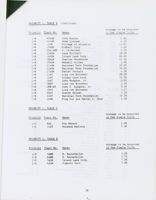
PRIORITY 1, TABLE A
Acreage to be Acquired
Priority
Tract No.
Owner
in Fee Simple Title
1-A
2ABH
MDI Marine Lab
2.00
1-A
8ABH
John Hodgkins
3.50
1-A
9ABH
Elizabeth Hodgkins
5.00
1-A
10ABH
Robert Wilcomb
6.00
1-A
13ABH
Mervin Manring
14.00
1-A
15ABH
Chauncy McFarland
6.50
1-A
16ABH
Robie Palmer
5.00
1-A
18ABH
Leon Liscomb
3.00
1-A
20ABH
Margaret Rockefeller
10.00
1-A
22ABH
Harry Owen
22.70
1-A
23ABH
Margaret Rockefeller
9.80
1-A
24ABH
Roger Emery et al
50.00
1-A
25ABH
Ralph Miro
35.00
1-A
26ABH
Mervin Manring
4.00
1-A
29ABH
Shirley Carter
20.50
1-A
35ABH
John Hodgkins
1.50
1-A
36ABH
Charles Hadley
0.70
1-A
37ABH
Eugene King
0.30
1-A
38ABH
Susan Jackson
5.20
1-A
39ABH
Estate of H. B. Gilbert
8.30
1-A
40ABH
Jackson Lab
6.50
1-A
41A-ABH
Charlotte Bordeau
15.00
1-A
45A-ABH
Mary Dunham
3.60
1-A
45B-ABH
MDI Astro. Lab.
6.85
1-A
46B-ABH
William Plissner
5.00
1-A
46C-ABH
Johnson Frazier
5.00
1-A
47ABH
Ina Salisbury
27.00
1-A
47A-ABH
John Kauffmann
5.00
1-A
48ABH
Roy McFarland
80.00
1-A
49ABH
Shepard Harris
47.50
1-A
55A-ABH
Jackson Lab
12.50
1-A
56ABH
Estate of Pauline Palmer
58.00
1-A
62ABH
Jordan Prince et al
8.00
1-A
68ABH
Earl Gooch
0.70
1-A
67ABH
Edwin Garrett
3.00
1-A
71ABH
Estate of Pauline Palmer
0.57
1-A
1A-AMD
TNC of Pine Tree State
0.70
1-A
9AMD
C. Jay
0.98
1-A
24AMD
W. Apel
6.00
1-A
25AMD
L. Kaskell
26.00
1-A
26-AMD
National Parks &
Conservation Assoc.
3.50
1-A
27AMD
L. Smallidge
25.00
1-A
28AMD
S. Fox III
9.00
1-A
30AMD
Unknown
1-A
32AMD
R. Rockefeller
32.00
16
PRIORITY 1, TABLE A
(continued)
Acreage to be Acquired
Priority Tract No.
Owner
in Fee Simple Title
1-A
1ASW
Stanley Grierson
3.50
1-A
4ASW
Charles Rich II
2.75
1-A
7ASW
Gladys Butler, Sally Hewlett,
Charles Morehouse
4.00
1-A
8ASW
Island Land Corp.
8.50
1-A
9ASW
Ava Gott
2.30
1-A
10ASW
Ben Worcester
14.00
1-A
12ASW
Leslie King
5.50
1-A
1A-AT
Avis Higgins
1.90
1-A
2AT
Janet Earl
5.50
1-A
3AT
Harriet Lunt
0.50
1-A
4AT
S. R. Clark
4.50
1-A
5AT
William Abbott
1.90
1-A
6AT
Mary Benson
2.08
1-A
7AT
Harvey Kelley et al
4.67
1-A
9AT
Douglas Gott
17.00
1-A
10AT
Lisa von Borowsky
49.00
1-A
13AT
National Park Foundation
5.00
1-A
23AT
William Willock, Jr.
1.00
1-A
24AT
Robert Rice
1.00
1-A
25AT
W. W. Commerdinger
1.40
1-A
26AT
The Nature Conservancy
0.25
1-A
1AG
Fred Rulison
21.00
1-A
3AG
Atwater Kent, Jr.
7.00
1-A
4AG
Jonathan Sprague
32.00
1-A
5AG
C. Wiseman and
Jonathan Sprague
3.00
1-A
3AWH
Sue Ellen Monroe
61.00
1-A
4ACI
Greening Island Trust
1.90
1-A
17-104
Secor
24.79 (Easement)
1-A
17-109
Nowee
24.00
1-A
17-110
Hamilton
0.25
PRIORITY 1, TABLE B
Acreage to be Acquired
Priority Tract No.
Owner
in Fee Simple Title
1-B
1ABH
Bernard Dowd
0.76
1-B
44ABH
Bernard Cough
20.00
1-B
45C-ABH
Harold Gibbs
8.28 (Exchanged)
1-B
45D-ABH
Terrance Kelly
1.30
(Purchased)
1-B
57ABH
Estate of Pauline Palmer
9.40
1-B
58ABH
Estate of Pauline Palmer
9.40
1-B
64ABH
Virginia Shaw
3.50
17
PRIORITY 1, TABLE B
(Continued)
Acreage to be Acquired
Priority
Tract No.
Owner
in Fee Simple Title
1-B
65ABH
John Rowley
0.60
1-B
66ABH
Anne Liscomb
6.00
1-B
LAMD
College of Atlantic
13.83
1-B
19AMD
Kimball Corp.
4.60
1-B
26A-AMD
C. Atcherson
3.50
1-B
13ASW
Lena Mitchell
18.00
1-B
16ASW
Island Land Corp.
40.00
1-B
18ASW
Charles Morehouse
22.50
1-B
19ASW
Wendell Gilley
2.00
1-B
21ASW
National Park Foundation
10.00
1-B
23ASW
National Park Foundation
16.00
1-B
27ASW
Parker Fernald
4.50
1-B
11AT
Lisa von Borowsky
28.00
1-B
12AT
Island Land Corp.
12.50
1-B
16AT
John Hodgdon, Jr.
0.92
1-B
18AT
Lisa von Borowsky
2.50
1-B
18B-AT
John F. Hodgdon, Jr.
0.20
1-B
19AT
Lisa von Borowsky
1.17
1-B
20AT
Steven Keiser
1.20
1-B
22AT
National Park Foundation
14.00
1-B
2AWH
Ping Sun and Marvel C. Chun
4.50
PRIORITY 1, TABLE C
Acreage to be Acquired
Priority Tract No. Owner
in Fee Simple Title
1-C
8AT
Eva Benson
2.08
1-C
14AT
Suzanne Madiera
5.30
PRIORITY 1, TABLE D
Acreage to be Acquired
Priority Tract No. Owner
in Fee Simple Title
1-D
5AMD
D. Rockefeller
3.00
1-D
6AMD
D. Rockefeller
3.75
1-D
5ASW
Island Land Corp.
7.00
1-D
6ASW
Timothy Gott
5.00
18
PRIORITY 2, TABLE A
Acreage to be Acquired
Priority
Tract No.
Owner
in Fee Simple Title
2-A
11AMD
Northeast Harbor Water Co.
6.00
2-A
23AMD
Mrs. Anna Maria Black
6.00
2-A
28A-AMD
C. Zimmerman
5.70
2-A
29AMD
Richard Irvin, Jr.
16.70
2-A
31AMD
Unknown
2-A
3ASW
Charles Rich
60.00
2-A
1A-AG
J. Perkins
12.00
2-A
1AWH
U. S. Coast Guard
11.75 (Transfer)
2-A
5ACI
Dunbar
13.60
2-A
6ACI
U.S. Coast Guard
3.40 (Transfered)
PRIORITY 2, TABLE B
Acreage to be Acquired
Priority
Tract No.
Owner
in Fee Simple Title
2-B
41B-ABH
Wesley Matthei
3.20
2-B
42ABH
Francis Howard
1.00
2-B
45E-ABH
Gary Dermott
5.36
2-B
46A-ABH
Steve Hulbert
27.00
2-B
10AMD
F. Baltzell
1.40
2-B
12AMD
Appalachian Mtn. Club
11.00
2-B
13AMD
Lisa McQuinn
0.29
2-B
14AMD
Robert & Cynthia Aiken, Jr.
0.16
2-B
15AMD
Robert Neuman
0.25
2-B
16AMD
V. Pomroy et al
0.60
2-B
17AMD
M. Gilley
0.80
2-B
18AMD
P. Bordeaux
0.85
2-B
20A-AMD
John Cochran
5.00
2-B
20B-AMD
Charlie & Sheila Cochran
4.06
2-B
21A-AMD
T. Reath
1.30
2-B
21B-AMD
H. Reath
1.464
2-B
22AMD
M. Atherton
9.00
2-B
15ASW
Gordon Mosley
15.00
2-B
24ASW
Helen Madiera
2.00
2-B
25ASW
Alexandra Wright
0.50
2-B
26ASW
Southwest Harbor Water Co.
0.50 (Transfer)
2-B
1AT
U.S. Coast Guard
2.50
2-B
15AT
Rose Edna Gallant
2.00
2-B
17AT
Robert Coler
0.74
2-B
21A-AT
Audrey Auchincloss
62.00
2-B
1ACI
Nadya, Bettina & Arn Pearson
0.24
2-B
2ACI
Elizabeth Kolm
0.07
2-B
3ACI
U. S. Coast Guard
10.00 (Transfer)
19
PRIORITY 2, TABLE D
Acreage to be Acquired
Priority
Tract No.
Owner
in Fee Simple Title
2-D
30ABH
George and Diana
0.37
Strawbridge, Jr.
0.12
2-D
31ABH
Delores Gower
4.50
2-D
43ABH
Horace Liscomb
0.289
2-D
7AMD
A. Menzietti
12.40
2-D
11ASW
John Stetson
00.2
02.0
20
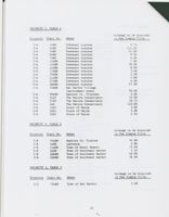
PRIORITY 3, TABLE A
Acreage to be Acquired
Priority
Tract No.
Owner
in Fee Simple Title
3-A
3ABH
Downeast Audubon
5.70
3-A
4ABH
Downeast Audubon
114.00
3-A
5ABH
Downeast Audubon
55.00
3-A
6ABH
Downeast Audubon
9.50
3-A
7ABH
Downeast Audubon
6.00
3-A
11ABH
Downeast Audubon
7.00
3-A
12ABH
Downeast Audubon
30.00
3-A
14ABH
Downeast Audubon
8.00
3-A
17ABH
Downeast Audubon
3.40
3-A
19ABH
Downeast Audubon
2.50
3-A
21ABH
Downeast Audubon
4.60
3-A
27ABH
Downeast Audubon
6.00
3-A
28ABH
Downeast Audubon
57.00
3-A
33ABH
Bar Harbor Village
Improvement Assoc.
36.00
3-A
29ASW
Hancock Co. Trustees
2.00
3-A
21AT
The Nature Conservancy
15.00
3-A
27AT
The Nature Conservancy
10.73
3-A
2AG
The Nature Conservancy
123.00
3-A
IASI
State of Maine
3.00
3-A
2ASI
State of Maine
5.00
3-A
3ASI
State of Maine
0.50
PRIORITY 3, TABLE B
Acreage to be Acquired
Priority
Tract No.
Owner
in Fee Simple Title
3-B
34ABH
Hancock Co. Trustee
34.00
3-B
4AMD
Lawrence
0.86
3-B
21AMD
Town of Mount Desert
15.00
3-B
2ASW
Town of Southwest Harbor
4.25
3-B
20ASW
Town of Southwest Harbor
40.00
3-B
22ASW
Town of Southwest Harbor
26.00
PRIORITY 3, TABLE C
Acreage to be Acquired
Priority
Tract No.
Owner
in Fee Simple Title
3-C
70ABH
Town of Bar Harbor
5.00
21
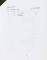
PRIORITY 3, TABLE D
Acreage to be Acquired
Priority Tract No. Owner
in Fee Simple Title
3-D
28ASW
Town of Southwest Harbor
2.00
3-D
28AT
Town of Tremont
8.00
NOTE: The parcels in the preceding lists are in numerical order by tract
number as depicted on the Park boundary map. Priorities for acquisition
identified in the left column of each Table are based on current
conditions. Adjustments may need to be made in response to owner
hardship or imminent danger of adverse impact to Park resources. Prompt
consideration will be given to offers to sell based on owner hardship
regardless of priority. In addition, parcels that are to be acquired by
exchange in return for deletion tracts will be acquired on an opportunity
basis.
22
2. Lands Outsice the Park Boundary - Lands outside the Park boundary
will be protected by conservation easements as authorized in P.L.
99-420. Conservation easements will be acquired by donation or purchase
from a willing seller. However, donation of easements on lands outside
the boundary will continue to be the preferred method of acquisition.
(See an additional provision for lands on Schooner Head under Protection
Methods ) Conservation easements acquired shall:
(A) protect the respective scenic, ecological, historic,
archeological or cultural resources existing on the parcels;
(B) preserve, through setback requirements or other appropriate
restrictions, the open, natural, or traditional appearance of the
shorefront when viewed from the water or from other public
viewpoints; or
(C) limit year-round and seasonal residential and commercial
development to activities consistent with the preservation of the
islands' natural qualities and to traditional resource-based land
use including, but not limited to, fishing, farming, silviculture,
and grazing.
In determining whether to accept or acquire conservation easements, the
following factors shall be considered by the National Park Service:
(A) the resource protection benefits that would be provided by
the conservation easement;
(B) the public benefit that would be provided by the conservation
easement;
(c) the significance of the easement in relation to the land
planning objectives of local government and regional and State
agencies;
(D) the economic impact of the conservation easement on local
livelihoods, activities, and government revenues; and
(E) the proximity of the parcel to the boundary of the Park and to
other parcels on which the Secretary maintains conservation
easements.
3. Deletion tracts, land outside the Park boundary that were determined
to be no longer important for Park purposes, may be used for exchange
purposes. While these lands are to be deleted, on the following tracts
we will seek to retain certain interest in the land to protect the
resource characteristics (wetlands, habitats, etc. ) that are important
to the Park.
Tract No.
2DBH No development on a portion of the tract.
3DBH No development on a portion of the tract.
5DBH No development below 100 foot contour line on Long Heath and
ad jacent to Kitteredge Brook.
23
8DBH No development within 100 feet of Bear Brook.
3DMD No commercial development along State Highway 102.
5DMD Single family residential use only.
1DT
No construction within 200 feet of Park boundary and no commercial
development on the parcel.
2DT
No commercial development.
4DT
No structure within 200 feet of the Park boundary and no commercial
development on the parcel.
Lands inside and outside of the Park boundary that become threatened
by development or other resource damage will require prompt consideration
and appropriate protection under available authorities and may include
acquisition outside of the established priority. Any purchase of land
or interest in land is subject to the availability of funds.
C. Compatibility Guidelines
In adopting a permanent fee boundary for Acadia, Congress indicated that
the level of private use and development existing as of November 1, 1985,
was compatible with the purposes of the Park. At the same time, by
providing authority to acquire these lands on an opportunity basis,
Congress recognized the need to preserve natural conditions and provide
for public use to meet long-range management goals of the Park.
These guidelines reflect the legislative intent concerning compatible
and incompatible uses of lands within and outside the Park boundary
as authorized.
1. Lands Inside the Park Boundary - Under P.L. 99-420 all development
existing as of November 1, 1985, is compatible and may expand within
specific limits. The following guidelines outline compatible and
incompatible uses of undeveloped and developed properties within the
Park and will be used by the National Park Service to determine when
property is being used in a manner which protects the scenic, historical,
cultural, and other values for which the Park was established.
a) Undeveloped Property - The development of undeveloped tracts
after November 1, 1985, shall be considered detrimental to Park
values. The clearing of vegetation or alterations to the surface
of the property will be considered compatible if for the following
reasons.
1. Maintenance and operation of roads and foot trails that existed
as of November 1, 1985.
24
2. The gathering, use, or removal of dead wood. Live, standing
trees may be cut by the owner only according to a plan approved
by the Park Superintendent.
Other land use activities such as dumping or storage of any trash,
refuse, or non-registered vehicles shall be considered incompatible.
b) Developed Property - The reconstruction of buildings shall
be considered compatible if the rebuilding is substantially as
these structures existed as of November 1, 1985, and is consistent
with the following criteria:
1. The development and use must comply with all applicable Federal,
State and local laws and regulations, and all necessary permits
must be obtained prior to commencement of reconstruction.
2. The exteriors of all structures shall be: finished with wood,
suitable wood-appearing substitutes, or stone; have non-reflective
roofs and sidings, and be colored to blend with their surroundings.
3. When possible structures shall be screened as to be unobtrusive
from existing roads, trails and viewpoints. This screening may
be accomplished by planting native vegetation and the color of
materials used.
4. Size of reconstruction shall conform to the 25% square footage
restriction set forth under "new construction."
5. Total height of reconstruction and any additive shall not exceed
32 feet as defined in more detail in Appendix A.
New construction must follow the guidelines for reconstruction
and shall be considered compatible if it is either attached
structural additions or accessory structures that do not exceed
an accumulative total of 25% of the square footage of the principal
structure as it existed as of November 1, 1985.
The construction of reasonable support development, such as roads,
small parking areas, water and sewage treatment systems, and docks
shall be considered compatible if they are essential to the support
and maintenance of the property.
The clearing of vegetation shall be considered compatible for:
1. Prudent management of wooded areas and fields, and the
cultivation and maintenance of lawns and personal gardens, in a
manner consistent with preserving scenic character of the property.
2. Excavation in connection with maintenance, reconstruction, or
construction either of compatible structures or of utility services
related to the use of the property.
25
3. Maintenance of the existing roads and foot trails.
4. The gathering, use, or removal of dead wood. Live standing
trees may only be cut by the owner according to a plan approved by
the Park Superintendent.
The dumping or storage of any trash, refuse, or non-registered
vehicles shall be considered incompatible.
c) Notification - The notification process for any proposed
development shall consist of:
1. The landowner shall notify the Park Superintendent in writing
as soon as possible prior to the proposed development. Appropriate
drawings, i.e. plans, elevations, and surveys as necessary are to
be included in the notification.
2. The Park Superintendent will review the proposed action and
within thirty days will determine in writing if the proposed
development is compatible with these guidelines or if additional
information is needed for a determination. The landowner will
have a reasonable opportunity to comment in writing on the
determination.
3. If the proposed development is determined to be detrimental
to Park values, the Park Superintendent will notify the owner of
his specific objections. The landowner may revise the proposal
for reconsideration.
If the property is being developed in a manner detrimental to the
scenic, historical, cultural, and other values, P.L. 99-420 provides
the authority for the National Park Service to acquire lands without
the consent of the owner. Before this authority would be used, the
National Park Service will provide written notice to the owner of
the property. Only after the owner has been given reasonable
opportunity to amend the actions considered detrimental to Park
values would the National Park Service seek to acquire the lands
without consent of the owner.
2.
Lands Outside the Park Boundary - Although the area known as Schooner
Head is outside of the Park, P.L. 99-420 stated that the Secretary is
authorized to acquire conservation easements if "the property is being
developed or proposed to be developed in a manner which is significantly
different from or a significant expansion of development existing as
of November 1, 1985. " The compatibility guidelines for developed
properties inside the Park boundary will be used by the National Park
Service in determining compatible uses of these lands.
If proposed development on Schooner Head is detrimental to Park values,
the National Park Service may acquire adequate interests to protect
those values.
26
3. Property Certification - Landowners are encouraged to cooperate
with the National Park Service to document the development existing as
of November 1, 1985. Owners may request the Superintendent to provide
a letter certifying that the development now in place is compatible
with the Park. This certification will be supported by photographs
and site plans documenting existing development in order to avoid any
future disagreements about what constitutes significantly different
or significant expansion of development within the Park.
D. Assessment of Impacts
The actions proposed in this Plan have no potential either individually
or accumulatively for causing significant environment impact. The
Plan is thus categorically excluded from compliance with the National
Environmental Policy Act.
27
APPENDIX A
Definitions Referring to Land Use Within the Park Boundarv
1. "Undeveloped property" shall mean any property without a building
located on the property as of November 1, 1985.
2. "Developed property" shall mean any property with a building located
on the property as of November 1, 1985.
3. "Development" shall mean any activity, action, or alteration which
changes undeveloped property into developed property.
4. "Principal structure" shall mean the largest residential structure
on a residential property. Relating to a commercial property, it shall
mean the largest commercial structure on the property. Relating to
a commercial property where both a residential structure and a commercial
structure exist, it will mean the larger of the two.
5. "25 per centum of the square footage of principal structure" shall
be calculated by the measurement of all primary habitable space.
6. "Attached structural additions" shall mean any development connected
on at least one building side to the principal building and customarily
incidental and subordinate to principal building or use.
7. "Accessory structure" shall mean any development which is located on
the same lot as the principal building, use of which is customarily
incidental and subordinate to the principal building or use, and which
use is not for overnight habitation. Accessory structure may include
storage sheds, docks, decks, garages, and patios. Accessory structure
shall also include guest houses used for overnight habitation without
cooking facilities.
8. "Building" shall mean an enclosed structure having a roof supported
by columns, walls, or cantilevers; and if separated by a party wall
without openings, it shall be deemed a separate "building."
"
9. "Guest house" shall mean an accessory structure without cooking
facilities, on the same lot as the principal building. Its purpose
being for the temporary accommodation of guests of residents living
in the principal building.
10. "Building height" for reconstructed or new constructed buildings
shall be limited to no more than 32 feet above average ground level.
The building height includes gables, dormers, stairwells, chimneys or
other protrusions in excess of two square feet in base area but does
not include vent stacks or such protrusions less than two square feet in
base area. The ground is the surface of the earth and does not include
walkways, decks, vegetation, artificial fill, retaining walls, or other
man-made alterations from the natural state.
APPENDIX B
Land Protection Overview
The following is a summary of the history of land protection within
the Park.
1. Method and amount of Federal Acquisition as of December 31, 1986.
Method
Acreage
Donation and Transfer
35,057.86
from other Federal agencies
Easement Donation
5,854.42
Total Acreage
Acreage acquired in Fee Title
36,653.55
Acreage acquired in Easement
5,854.42
Acreage Disposed
1,595.69
Total Federal Acreage Retained
40,912.28
2. Summary of Retained Uses December 31, 1986.
Type of Retained use
Number
Limited Term Use and Occupancy
0
Life Estate
0
Land Protection Program Status
Date
Authorized Ceiling
Appropriations
Unobligated
December 31, 1986
$9,100,000
$3,500,000
$3,500,000
APPENDIX C
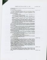
PUBLIC LAW 99-420-SEPT. 25. 1986
100 STAT 955
Public Law 99-420
99th Congress
An Act
To establish a permanent boundary for the Acadia National Park in the State of
Sept. 25. 1986
Maine. and for other purpc og
(S. 720|
Be it enacted by the Senate and House of Representatives of the
United States of America in Congress assembled.
TITLE I
SEC. 101. BOUNDARIES OF ACADIA NATIONAL PARK.
Conservation
Public
In order to protect and conserve the land and water resources of
information
Acadia National Park in the State of Maine hereinafter in this title
16 USC 341 note.
referred to as "the Park"), and to facilitate the administration of the
Park, the boundary depicted on the map entitled "Acadia National
Park Boundary Map", numbered 123-80011. and dated May 1986
(hereinafter in this title referred to as "the map'') is hereby estab-
lished as the permanent boundary for the Park. The map shall be on
file and available for public inspection in the offices of the National
Park Service. Department of the Interior. and it shall be made
available to the Registry of Deeds for Hancock and Knox Counties,
Maine.
SEC. 102. LANDS WITHIN BOUNDARIES.
Gifts and
(a) The Secretary of the Interior (hereinafter in this title referred
property
16 USC 511 note.
to as "the Secretary") is authorized to acquire lands and interests
therein within the boundaries of the Park by donation. exchange (in
accordance with this section). or purchase with donated or appro-
priated funds, except that-
(1) any lands or interests therein owned by the State of Maine
or any political subdivision thereof may be acquired only by
donation or exchange: and
(2) privately owned lands or interests therein may be acquired
only with the consent of the owner thereof unless the Secretary
determines that the property is being developed or proposed to
be developed in a manner which IS detrimental to the scenic,
historical. cultural, and other values for which the Park was
established.
(b)(1) Not later than 6 months after the enactment of this Act. the
Secretary shall publish specific guidelines under which determina-
tions shall be made under subsection (a)22. The Secretary shall
provide adequate opportunity for public comment on such guide-
lines. The guidelines shall provide for notice to the Secretary prior
to commencement of any proposed development within the bound-
aries of the Park. The Secretary shall provide written notice to the
owner of the property of any determination proposed to be made
under subsection (a)(2) and shall provide the owner a reasonable
opportunity to comment on such proposal.
(2) For purposes of this section. except as provided in paragraph
(3), development or proposed development of private property within
as (1.96)
100 STAT. 956
PUBLIC LAW 99-420-SEPT. 25, 1986
the boundaries of the Park that is significantly different from. or a
significant expansion of. development existing as of November 1.
1985, shall be considered by the Secretary as detrimental to the
values for which the Park was established.
(3) Reconstruction or expansion of a private or commercial build.
ing shall not be treated as detrimental to the Park or as an
incompatible development within the meaning of this section if such
reconstruction or expansion IS limited to one or more of the
following:
(A) Reconstruction of an existing building.
(B) Construction of attached or accessory structural additions.
which do not exceed 25 per centum of the square footage of the
principal structure.
(C) Construction of reasonable support development such as
roads. parking facilities. water and sewage systems, and dock
facilities.
Real property.
(c)(1) The owners of any private property within the Park may, on
the date of its acquisition by the Secretary and as a condition of such
acquisition. retain for himself and his successors or assigns a right
to use and occupancy for a definite term of not more than 25 years,
or ending at the death of the owner, or his spouse, whichever is
later. The owners shall elect the term to be reserved. The Secretary
shall pay to the owner the fair market value of the property on the
date of such acquisition, less the fair market value, of the right
retained by the owner.
(2) Any such right retained pursuant to this subsection shall be
subject to such terms and conditions as the Secretary may prescribe
and may be terminated by the Secretary upon his determination
and after reasonable notice to the owner thereof that such property
is being used for any purpose which is incompatible with the
administration of the Park or with the preservation of the resources
therein. Such right shall terminate by operation of law upon
notification to the owner by the Secretary and tendering to the
owner the amount equal to the fair market value of that portion
which remains unexpired.
(dx() In exercising his authority to acquire lands by exchange
pursuant to this title. the Secretary may accept title to non-Federal
property located within the the boundary of the Park and may
convey to the grantor of such property any federally owned property
under the jurisdiction of the Secretary which lies outside said
boundary and depicted on the map. Properties so exchanged shall be
approximately equal in value, as determined by the Secretary,
except that the Secretary may accept cash from or pay cash to the
grantor in such an exchange in order to equalize the value of the
properties exchanged.
(2) Federally owned property under jurisdiction of the Secretary
referred to in paragraph (1) of this subsection which is not ex.
changed within 10 years after enactment of this Act, shall be
conveyed to the towns in which the property is located without
emcumbrance and without monetary consideration, except that no
town shall be eligible to receive such lands unless, within 10 years
after enactment of this Act. lands within the Park boundary and
owned by the town have been acquired by the Secretary.
(e) Notwithstanding any other provision of this section. lands
depicted on the map referenced in section 101 and identified as
10DBH and 11DBH known as the "Bar Harbor Sewage Treatment
Plant"; 14DBH known as the "New Park Street Ballfield"; and
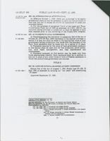
PUBLIC LAW 99-420-SEPT. 25, 1986
100 STAT. 957
15DBH known as the "Former Park Headquarters'; shall be con.
veyed by the Secretary, without monetary consideration. to the town
of Bar Harbor. Maine, within 180 days following the enactment of
this Act. The real property conveyed pursuant to this subsection
shall be used and retained by the town for municipal end public
purposes. Title to the properties conveyed pursuant to this subsec.
tion shall revert to the United States if such property or any portion
thereof is conveyed by the town to another party or used for
purposes other than those specified in this subsection.
(f) Notwithstanding any other provision of this section. land de-
picted on the map identified as 4DBH. located in the village of Town
Hill. Maine, shall be conveyed by the Secretary without monetary
consideration. to the town of Bar Harbor, Maine. as soon as prac-
ticable following the enactment of this Act. subject to such terms
and conditions. including appropriate reversionary provisions. as
will in the judgment of the Secretary provide for the development
and use of such property by any town which so desires as a solid
waste transfer station in accordance with a plan that is satisfactory
to the town and the Secretary. The Secretary shall (subject to the
availability of prior appropriations) contribute toward the cost of
constructing such transfer station the lesser of-
(1) $350,000, or
(2) 50 per centum of the cost of such construction.
(g) Notwithstanding any other provision of this section. the Sec-
retary is authorized to acquire by donation or exchange lands or
interests therein in the area identified on the map as "Schooner
Head", which is outside the boundary of the park. The Secretary is
further authorized to acquire conservation easements on such lands
by purchase with donated or appropriated funds if he determines
after written notice to the owner and after providing a reasonable
opportunity to comment on such notice, that the property is being
developed or proposed to be developed in a manner which is signifi-
cantly different from or a significant expansion of development
existing as of November 1. 1985, as defined in subsection (b) of this
section.
(hri) The Secretary is authorized to acquire conservation lease-
Conservation
ments by purchase from a willing seller or by donation on parcels of
land adjacent to the Park on Schoodic Peninsula. the islands of
Hancock County, and the islands of Knox County east and south of
the Penobscot Ship Channel. except such islands as lie within the
town of Isle au Haut, Knox County. Parcels subject to conservation
easements acquired or accepted by the Secretary under this subsec-
tion must possess one or more of the following characteristics:
(A) important scenic. ecological. historic. archeological, or
cultural resources:
(B) shorefront property; or
(C) largely undeveloped entire islands.
(2) Conservation easements acquired pursuant to this subsection
shall-
(A) protect the respective scenic. ecological. historic. ar.
cheological, or cultural resources existing on the parcels:
(B) preserve, through setback requirements or other appro-
priate restrictions, the open. natural. or traditional appearance
of the shorefront when viewed from the water or from other
public viewpoints: or
(C) limit year-round and seasonal residential and commercial
development to activities consistent with the preservation of the
100 STAT. 958
PUBLIC LAW 99-420-SEPT. 25, 1986
islands' natural qualities and to traditional resource-based land
use including, but not limited to, fishing, farming, silviculture,
and grazing.
(3) In determining whether to accept or acquire conservation
easements pursuant to this subsection, the Secretary shall consider
the following factors:
(A) the resource protection benefits that would be provided by
the conservation easement:
(B) the public benefit that would be provided by the conserva-
tion easement;
(C) the significance of the easement in relation to the land
planning objectives of local government and regional and State
agencies:
(D) the economic impact of the conservation easement on local
livelihoods. activities. and government revenues: and
(E) the proximity of the parcel to the boundary of the Park
and to other parce!s on which the Secretary maintains con-
servation easements.
(4) For purposes of this subsection. the term "conservation ease-
ment" means a less-than-fee interest in land or a conservation
restriction as defined in section 476 through 479-B inclusive, as
amended. of title 33 of the Maine Revised Statutes of 1964, as in
effect on the date of the enactment of this Act.
(5) No easement may be acquired by the Secretary under this
subsection without first consulting with. and providing written
notification to. the town in which the land is located and the Acadia
National Park Advisory Commission established by section 103 of
this title. In providing such notification, the Secretary shall indicate
the manner and degree to which the easement meets the criteria
provided in this subsection.
(i) Nothing in this section shall be construed to prohibit the use of
condemnation as a means of acquiring a clear and marketable title,
free of any and all encumbrances.
(j)(1) Notwithstanding any other provision of this section. the
Secretary shall accept an offer of the following from the Jackson
Laboratory (a not-for-profit corporation organized under the laws of
Maine):
(A) Lands depicted on the map as 55 A ABH which are held in
fee by the Jackson Laboratory.
(B) A conservation easement on lands depicted on the map
identified as 55 ABH (the developed property known as
"Highseas"). The easement shall prohibit subdivision of such
land or any further significant development on such lands.
except as permitted by the guidelines published under section
102(b)(1).
(2) Upon receipt of the lands and easement described in paragraph
(1), the Secretary shall transfer to the Jackson Laboratory the lands
depicted on the map as 8 DBH and 9 DBH. Any disparity in the fair
market value of the lands and easement referred to in paragraph (1)
and the lands described in the preceding sentence shall be equalized
as provided in section 102(d)(1).
(k) For purposes of subsection (a)(2), the construction of one single
family residence on Burnt Porcupine Island by the owner of the
Island shall not be treated as detrimental to the scenic, historic.
cultural. or other values for which the park was established if.
before such construction commences, the Secretary has reviewed
PUBLIC LAW 99-420-SEPT. 25, 1986
100 STAT. 959
and approved plans for the size, location and architectural design of
the structure.
SEC. 103. ADVISORY COMMISSION.
16 USC 341 note
(a) There is hereby established an Acadia National Park Advisory
Commission (hereinafter referred to as "the Commission"). The
Commission shall be composed of 16 members appointed by the
Secretary as follows:
(1) 3 members at large.
(2) 3 members appointed from among individuals rec-
ommended by the Governor of Maine.
(3) 4 members. appointed from among individuals rec-
ommended by each of the four towns on the island of Mount
Desert.
(4) 3 members appointed from among individuals rec-
ommended by each of the three Hancock County mainland
communities of Gouldsboro. Winter Harbor. and Trenton.
(5) 3 members. appointed from among individuals rec-
ommended by each of the three island towns of Cranberry Isles,
Swans Island. and Frenchboro.
(b) The terms of the Commission members shall be 3 years except
that, for initial appointments under each paragraph. one member
shall serve for a term of one year. and one member shall serve for a
term of 2 years.
(c) The Commission shall elect its own chairman and adopt its own
bylaws. Any vacancy on the Commission shall be filled in the same
manner in which the original appointment was made.
(d) Members of the Commission shall serve without compensation
as such. except that the Secretary is authorized to pay the expenses
reasonably incurred by the Commission in carrying out its respon-
sibilities under this title.
(e) The Secretary shall consult with the Commission on matters
relating to the management and development of the Park, including
but not limited to each of the following:
(1) The acquisition of lands and interests in lands (including
conservation easements on islands).
(2) Termination of rights of use and occupancy.
(f) The Commission established under this section shall terminate
20 years after the enactment of this Act.
SEC. 10%. BEAR ISLAND.
16 USC 341 note.
(a) Notwithstanding any other provision of law. Federal property
located on Bear Island in the town of Cranberry Isle shall. with the
concurrence of the agency having custody thereof. be transferred
without consideration to the administrative jurisdiction of the Sec-
retary for use by him in carrying out the provisions of the title. Such
Federal property shall not be developed by the Secretary in a
manner which would provide for or encourage intensive visitor use.
(b) The Secretary is authorized to make improvements to the
Federal property on Bear Island as he deems appropriate for the
protection of adjacent private property.
SEC. 105. TOWN OF ISLE AU HAUT.
16 USC 341 note.
The provisions of this title shall not apply to those portions of the
Park lying within the Town of Isle au Haut, Maine. which lands
shall continue to be governed by the provisions of Public Law
97-335.
16 USC 341 note.
100 STAT. 960
PUBLIC LAW 99-420-SEPT 25, 1986
16 USC 34i note.
SEC. 106. AUTHORIZATION OF APPROPRIATIONS
Effective date.
(a) Effective October 1, 1986. there are authorized to be appro-
priated such sums as may be necessary to carry out the provisions of
this title, but not to exceed $9,100,000 for acquisition of lands and
interests therein.
(b) For the purposes of paragraph 7(a)(3) of the Land and Water
Conservation Fund Act of 1965 as amended (16 U.S.C. 4601-9), the
statutory ceiling provided in subsection (a) shall be deemed to have
been enacted prior to the convening of the Ninety-fifth Congress.
16 USC 341 note.
SEC. 107. PAYMENTS TO LOCAL GOVERNMENTS.
(a) Notwithstanding the limitation in subsection 3(d) of the Act of
31 USC 6904.
October 20, 1976 (90 Stat. 2662) payments in the manner provided in
section 3 of that Act shall be made to the appropriate units of local
government having jurisdiction over lands with the boundary of the
Park. Such payments shall be made only for a period of 12 years.
(b) Payments received by the units of local government pursuant
to this section shall be used only for fire protection, police protec-
tion, solid waste management, and road maintenance and
improvement.
(c) Payments pursuant to this section may be made only from
funds appropriated therefor. Such payments shall be in addition to
and not in place of any other funds or form of Federal assistance to
which the units of local government are entitled.
TITLE II
SEC. 201. CAPE COD NATIONAL SEASHORE ADVISORY COMMISSION.
Section 8(a) of the Act of August 7, 1961 (Public Law 87-126; 75
16 USC 159b-7.
Stat. 292) is amended by striking out "ten years" and substituting
'30 years".
Approved September 25, 1986.
LEGISLATIVE HISTORY-S. 720:
HOUSE REPORTS: No. 99-572 (Comm. on Interior and Insular Affairs
SENATE REPORTS: No. 99-198 (Comm. on Energy and Natural Resources).
CONGRESSIONAL RECORD:
Vol. 131 (1983): Dec. 3. considered and passed Senate.
Voi. 132 (1986): May 5. considered and passed House. amended.
June 6. Senate concurred in House amendment with amend-
ments.
July 24. House concurred in certain Senate amendments. in
another with an amendment.
Sept. 11. Senate receded from its amendment.
APPENDIX E
L1425 (NAR L)
ACAD
Mr. John L. Bryant, President
National Park Foundation
1825 K Street NW - Suite 712
Washington, DC 20006
Dear John:
A parcel of land having an area of approximately four acres identified on the
proposed legislation Land Status Map of January 1983 for Acadia National Park
as Tract 26 ND has been offered for sale by the representation for the
Estate of Sadie Marcus. The parcel is completely surrounded by Park property
and should be part of the Park.
As you know we lack both the necessary authority and funds to purchase lands at
Acadia National Park at this time. The nine residuary legattes under the will
of the late Sadie Marcus are not receptive to a donation of these lands. The
value of the parcel is estimated at
.
I would appreciate it greatly if the National Park Foundation could assist us
by acquiring and holding this parcel at this time with the understanding that
it will be acquired by the National Park Service after the requisite legislative
authority is enacted. It is understood that should the National Park Service
be unable or detline for policy reasons to purchase the parcel at a future date
disposition of the parcel by the National Park Foundation would be without
liability to the Government.
Thank you for your consideration in this matter.
Sincerely,
Merbert S. Cables, JI.
Regional Director
PKCOTTER:pts 1/18/85
Suo:
AJAIN OHICAI
Oans.
United States Department of the Interier
E.
Div.
w
Uist
SERVICE
NATIONAL PARK SERVICE
received
PARK
NORTH ATLANTIC REGION
7.1979
IN REPLY REF
7
are
15 STATE STREET
BOSION. MASSACHUSE IS 02109
U
MAY
L1425
NATIONAL
e
&
6
NAR
(L)
May 3, 1979
ACAD
ACADIA
Naum Tech.
n.e
Memorandum
To:
Superintendent, Acadia National Park
From:
Regional Director, North Atlantic Region
Subject:
Acadia National Park - Acquisition of Land - Marjorie Bragg,
Tract 26 AT
Reference is made to your memorandum of April 3, 1979, concerning the
acquisition of the above tract of land by The Nature Conservancy.
Enclosed is a letter of April 26, 1979, from Acting Associate Director
Surles to Mr. David Morine, The Nature Conservancy. The letter to
Mr. Morine indicates the intent of the National Park Service to acquire
the property from The Nature Conservancy when legislation is passed.
Jack Jack E. Stark E. Stand
Enclosure
L1425-640
APR 26 1979
it. Dove irrine
ilie Nature Conservancy
1800 North Part street
Arlington, Virginia 22209
Dear Cave:
The pictional Facid Service has identified 10 islanis 011 the proposed
illster Plan for Acatia rational pack that about be acquired because of
their exerplary scenic UL ecological significence. Ironce Island is
one of these, Frimarily because of its interpretive valux for scal and
gull habitat.
should the littic conservancy be able to purchase this island from the
present owner, Mr. Margerie Brain, the lotional Pack Service will make
every effort to PURCHASE the isinnd from tix Conservancy, s.hcn legislation
is passed chabiling Aciria National Parx to acquire lands.
The efforts of the nature Conservancy to preserve lands initiat to
future national Park paragement are ucepily expreciated.
Sincerely yours,
ASgd) L. E. Surles
Asting Associate Director
CC:
Regional Director, MAD
61425-NAR (L)
MAY 5, 1975
Mr. John L. Bryant, JI.
Prosident
National Park Foundation
Washington, DC 20240
Dear 118. Bryant:
By Proclamation No. 1339 of July 8, 1916 (39 Stat. 1785) the Sieur
de
Monts National Monument was authorized. The name was changed to the
Lafayette National Park by Act of February 26, 1919 (40 stat. 1178) and
to the Acadia National Park by Act of January 19, 1929 (45 Stat. 1083).
Nuxerous boundary revisions have been authorized since 1929 to provide
for transfer, exchange and acquisition by donation. there is no acreage
limitation or authorization for appropriation of funds under existing
legislation. We have authority to accept land liv donation only within
Hancock County and the islands in Knox County to tile ship channel.
The naster plan for the Acadia National Tark is in the final staces of
preparation and in house review is scheduled during the next three to
four months. Public review and comment is propneous in early Fall of this
year. After public review and consent, the plan should be approved and
legislation initiated to establish a permanent boundary. Losislative
support data is scheduled in 1976. It is proposed to acquire certain
tracts for development and to provide more manageable units by eliminating
certain inholdings.
The major portion of the other half of Baker Island, consisting of 70 acres,
is in imminent danger of development. Property is available for sale and
the owner, winifred Couites, Garter Notch Road, North Conway, New Hairshire
03860, has had s firm offer of
Mr. Coulter has indicated be will
be willina to accept payment for the property based 011 A three-year plan.
Total would be
for the property plus $4,700 for interest that would
accrue in the second and third year at 8% plus closing expenses. The first
payment is estinated at
to be applied to the purchase price plus
the
interest and expenses.
The United States premently owns 84.7 acres of Baker Island. with the
acquisition of the 70-acre tract, three small inholding remain to be
acquired at a later aate. The person who madc the firm offer of
intends to construct a dwelling on the property and probably additional
dwellings for his children. The remainder of Baker Island not owned by
the United States is proposed for aquisition under the draft master plan.
Approximately 9.1 acres of land fronting on the Schnoner Head Road
designated as Tract 12-120 is on the market for
This tract
could be subdivided into SOVER bomesites with frontage on the Schooner
Head Road. The land is relatively flat and well drained. Present forest
cover is a mixture of mature hardwood trees that survived the 1947 fire.
subsequent growth since the fire has been hardwoods with oak as the
predominant species. This tract is presently surrounded on three sides
by the park. The owner, John Beer, Ichooner Head Road, Bar Marbor, Naine,
has an offer to purchase a lot out of the 9.1 acres. The tract is
included in the boundary proposal of the draft master plan. The owner
has offered to sell the property for the inclusion in the Acadia National
Park.
The owner, Annie selieski, 72 Ledgeleen Avenue, Bar Marbor, Maine, contacted
a representative of the National Part Service to offer Tract 12-118,
containing 1.8 acree of land, for sale to the Government. This tract is
located adjacent to and with access to state Hichway #3. The property has
s gradual slope suitable for construction of a residence. Old foundations
would indicate a previous structure. The area is primarily open field
with three or four apple trees and some encroacnment on the sides of the
lot from the surrounding forest. This tract is completely surrounded by
the Acadis National park. The owner is asking
for the property and
has contacted a local businessnas, offerine to sell the tract to him.
The owner of a 3/5's interest in Tract 04-145 has offered to sell her
interest in a 5-acre tract of land for
The owner, Mrs. Gerald
13AT
Kosley of Bar Harbor, Naine, expressed an intent to conduct logging
operations on the tract. The owner of the remaining 2/3's interest
cannot be Located.
The owner of a 20-acre tract of land situated between Tracts 10-113, 10-116
and 10-117 visited the part headquarters on April 3, 1975 and advised that
he does not agree with our boundary of the aljoining proparty. The owner,
Roger McFarland, Bar Harbor, Maine, has the tract of land on the market for
sale and expressed an intent to cut the times to his alleced line and sell
the property after Loaging operations were completed. The owner has not
indicated an asking price for the property.
Enclosed is one copy each of Land Status Maps 04, 10, 12 and 14 delineating
the above tracts of land.
2
F,
It is requested What the. National Park Foundation acquire the above
tracts of land in wiels present state pending enactment of levislation
and appropriation of furds for the purchase of the properties. If funds
are not available for the acquisition of All tracts, it is requested that
priority be given to the acquisition in the order listed above. Appraisal
and title reports will be obtained as soon as you indicate you are in a
position to proceed with the acquisition.
If you have any questions relating to the above, plaase contact Mr. Coleman
at 617-223-3780.
sincerely yours,
75gd.) DAVID is. LICHTE
David A. Ricise
Acting Regional Director
Inclosures
TRColeman: dr 5/2/75
CC: Chief, Division of Land Acquisition, WASO
Superintendent, Acadia NP
3
p.
CONTENTS NOTES
IAL REC United States Department of the Interior
sunt.
City
Admin.
Rea 5/11
NATIONAL PARK SERVICE
MAY 1 1 1978
SEADIA
PARK.
NORTH 4 TLANTIC REGION
IS STATE STREET
IN UFPLY REFER
NATIONAL
BOSTON. MASSACHUSEITS 02109
L1425-NAR (L)
May 8, 1978
ACAD
Memorandum
Admin
To:
Superintendent, Acadia National Park
Flie
From:
Regional Director, North Atlantic Region
Subject: Acadia National Park - Acquisition by Nature Conservancy,
John E. Smith
Land and Water Conservation funds available to our Land Acquisition
Division can be provided to clear the title if the property is conveyed
to the United States of America. At this time, the only method of acqui-
sition is by donation. If The Nature Conservancy is willing to convey this
property at this time by donation, funds will be requested to clear the
title through a title insurance company.
If The Nature Conservancy is not willing to convey the property by donation
at this time but will hold the property until funds are available for
acquisition by the United States, we will pay the fair market value at
the time of conveyance to the United States. It should be noted that
the appraisal of this tract of land obtained by this office is in the amount
of
which is on the basis that the title is free and clear of all
liens and encumbrances. To obtain the amount of
for this tract,
the owner should clear the title.
Jack Jack E. Stark E. Stank
Note: PROPERTY was Acquired by NAture Consecuancy in may 5, 1978
it miller
(1A-AMD)

