
From collection Jesup Library Maine Vertical File

Page 1
Page 2
Page 3
Search
results in pages
Bicycle Guide to Acadia National Park
CARRIAGE PA IS:
NEW EAGLE LAKE
AD:
Started in 1915, the carriage path system
Although it may serve as an approach road to
reflects the creative talents of its designer and
the carriage paths for bicyclists coming from
Bicycle Guide
patron, John D. Rockefeller, Jr. Originally,
Rockefeller had the carriage roads built so
Bar Harbor, the new Eagle Lake Road also
that he and others could ride carriages free
bears two-way motor vehicle traffic. USE
To
from the presence and noise of motor
WITH CAUTION not only because it is narrow,
vehicles. Today, in the spirit of that tradition,
but also because the road has shoulders that
park visitors bicycle, ride horses, and walk on
may drop eight or more inches from the
Acadia
these paths which remain closed to cars.
asphalt surface.
Acadia National Park maintains about 16
From Bar Harbor, follow the West Street
National Park
miles of the 51-mile carriage path system for
extension 4/5 mile west of Bar Harbor. Turn
bicyclists. These bicycling routes, including
right onto the New Eagle Lake Road which
the loops around Eagle Lake, Witch Hole
Pond, and Paradise Hill, have been impressed
swings northwest beneath an underpass and
with ground stone to provide traction and
then turns south to parallel Duck Brook. At the
support for small diameter tires. All of these
three-arched stone bridge, you may turn right
routes feature rolling hills and beautiful
onto the Witch Hole Pond carriage path.
scenery.
Alternately, you may continue south on the
Three points of entry permit access to the
New Eagle Lake Road to State Route 233.
carriage roads reserved for bicyclists:
Turning right on State Route 233 and riding 1/4
1) This trailhead is located at the northwest
mile on a wide paved shoulder leads to the
end of the Visitor Center parking lot. The
Eagle Lake Parking Area, which serves as an
trail, covered with gravel, winds through 1/2
entrance to the Witch Hole Pond and Eagle
mile of forest before joining the carriage
Lake carriage paths.
road near Witch Hole Pond.
GO
2) This entry point is located at the Eagle Lake
Parking Area, north of Eagle Lake on the
north side of State Route 233.
3) This approach is via an extension of the
carriage road which intersects the Park
Loop Road at the Bubble Pond Parking Area.
MAIN ROAD WITH BIKE
Routes designated as "other carriage paths,"
open for horseback riding and not surfaced
SHOULDER:
with ground stone, are not maintained as
bicycle routes. Weather and the frequency of
Long-term plans call for the construction of
horse traffic change conditions on the "other
asphalt-surfaced bike routes along the
carriage paths," but they tend to have a softer,
shoulders of all major roads on Mt. Desert
looser surface, suitable for balloon-tired bikes
Island. As the bicycle map indicates, the plan
and non-motorized mountain bikes, but less
is only partially complete.
suitable for narrow-tired bikes.
PLEASE OBSERVE THE
PARK LOOP ROAD:
SEAL COVE & WESTERN
FOLLOWING PRECAUTIONS:
Various state and local roads provide access
MOUNTAIN ROADS:
to the 19-mile Park Loop Road. Bicyclists are
Although motor vehicles are permitted on
1) Obey all applicable traffic regulations.
required to share this asphalt-surfaced Loop
these roads, traffic is always light. The stony
Road with motor vehicles. During the summer
gravel-surfaced roads join to form an 8-mile
2) Ride single file in the direction of traffic.
months, consider planning your bike trip
loop which leads through a spruce forest.
around the Loop Road in the early morning or
Access is via State Route 102 which
late in the day when traffic is light. A 12-mile
intersects the Seal Cove Road about 1/2 mile
3) Use hand signals to indicate stopping
stretch of the Park Loop Road between Sieur
north of Southwest Harbor.
and turning.
de Monts and the Stanley Brook Road (near
Seal Harbor) is a 2-lane, one-way road.
4) Avoid drain grates, soft shoulders, and
BICYCLISTS MUST OBEY ONE-WAY
other road surface hazards.
ROAD REGULATIONS. The remainder of
the Park Loop Road is open to two-way traffic.
SCHOODIC PENINSULA:
5) Remain clearly visible at night, equipped
A 3 2/10 mile spur road off of the main Park
50 miles from Bar Harbor is Schoodic
with adequate lighting.
Loop winds up to the summit of Cadillac
Peninsula, the only section of Acadia National
Mountain. The 8% grade may be tiring, but the
Park on the mainland. Follow Route 1
MOPEDS AND OTHER MOTORIZED BIKES
view from Cadillac compensates for sore
northeast from Ellsworth and turn south on
ARE CONSIDERED MOTOR VEHICLES AND
muscles.
State Route 186 to the entrance to Schoodic
CAN ONLY BE RIDDEN ON ROUTES
Peninsula. Park your car at Frazer Picnic area,
DESIGNATED FOR AUTOMOBILES.
near the Park entrance. The six mile asphalt
road parallels the rugged seacoast and
NON-MOTORIZED MOUNTAIN BIKES ARE
includes gentle dips and rises. The loop road is
PERMITTED ON ALL CARRIAGE PATHS BUT
open to motorized vehicles, but traffic is much
NOT ON TRAILS.
HIO TRAIL:
lighter than on the major roads on Mount
Desert Island. BICYCLISTS MUST OBEY
Beginning at Loop C in Seawall Campground,
ONE WAY ROAD REGULATIONS.
SUGGESTED BIKE ROUTES
the 2 1/2 mile Hio Trail winds through a mixed
forest of hardwoods and evergreens before
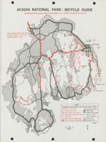
(Schoodic route not shown on map.)
Since main roads bear the heaviest traffic,
joining State Route 102. Surfaced with stones
particularly in July and August, you may
and gravel, this fairly level road is open for
choose to avoid them depending upon your
horseback riding and closed to motor vehicles.
destination. Please see map key. It will help
The trail does not form a loop. You must either
you locate suggested bike ways (shown in red
retrace your original route or return via State
on map) and less traveled thoroughfares such
Routes 102 and 102A. The state routes have
as "other paved roads" and "other carriage
hard surfaces, but road shoulders are not
roads." You effent bicycles in nearby towns.
paved and automobil traffic may be heavy in
Popular bikew S are described below.
summer.
ACADIA NATIONAL PARK : BICYCLE GUIDE
SUGGESTED BICYCLE ROUTES IN RED. ALL OTHER ROUTES IN BLACK.
3
102
FOR DESCRIPTION OF BICYCLE
198
Visitor
ROUTES, REFER TO TEXT ON
Center
REVERSE SIDE OF MAP.
Witch
Hole
Pond
West
Bar Harbor
0
6
233
Somesville
198
Eagle
Lake
198
Cadillac
Mt.
102
Bubble
3
Pond
Long Pond
Echo
Jordan
Lake
Pond
Thunder Hole
102
Seal
(Cove
Blackwoods
Otter Point
Pond
Campground
Northeast
Harbor
Southwest
Cove
Road
Harbor
KEY
Suggested bicycle routes in red. All other routes in black.
Park Loop Road
Carriage paths
Carriage paths
Main roads
New Eagle Lake Road
Other paved roads
Seal Cove & Western Mt. Rds.
Gravel roads
102A
Hio Trail
Park boundary
Bike trail to carriage path
Park land
Main road with bike shoulder
Private land
Seawall
1986
Campground
0
1/2
1
Miles
N
Bass
Harbor

