
From collection Jesup Library Maine Vertical File

Page 1
Page 2

Page 3
Page 4
Page 5
Page 6
Page 7
Page 8

Page 9
Page 10
Page 11
Page 12
Page 13
Page 14
Page 15
Page 16
Page 17
Page 18
Page 19
Search
results in pages
Maine's First Buildings: The Architecture of Settlement, 1604-1700
MAINE'S FIRST BUILDINGS
The Architecture of Settlement, 1604-1700
By Robert L. Bradley, Ph.D.
Architectural Historian
Maine Historic Preservation Commission
MAINE'S FIRST BUILDINGS
he Architecture of Settlement, 1604-1700
Robert L. Bradley, Ph.D.
chitectural Historian
ine Historic Preservation Commission
This booklet was published in April, 1978 by the
Maine Historic Preservation Commission with private
funds provided by Citizens for Historic Preservation and
the Society for the Preservation of Historic Landmarks
in York County, Inc., matched by Federal funds provided
by the Commission through the Office of Archaeology
and Historic Preservation, Heritage Conservation and
Recreation Service, Department of the Interior.
EARLE G. SHETTLEWORTH, JR.
State Historic Preservation Officer
THE MAINE HISTORIC PRESERVATION COMMISSION was created by the 105th Legislature in 1971 to administer
the National Register Program in Maine. The Commission is responsible for conducting a statewide survey
of historic, architectural, and archaeological resources and the nomination of properties to the National Reg-
ister of Historic Places. In addition, the Commission administers a 50% matching Federal Grants-in-Aid
Program for the excavation of archaeological sites and the restoration of historic buildings.
CITIZENS FOR HISTORIC PRESERVATION is a state-wide historic preservation organization linking the efforts
of local preservation groups and historical societies. Citizens publishes a quarterly newsletter covering local,
state, and national preservation activities and since 1971 has sponsored annual conferences on preservation
issues, including Historic Districts, Buying Antique Houses, and Maine Archaeology.
THE SOCIETY FOR THE PRESERVATION OF HISTORIC LANDMARKS IN YORK COUNTY, INC., is a non-profit organ-
ization dedicated to the preservation of York's colonial heritage. The Society maintains Jefferds Tavern,
the
George Marshall Store, the John Hancock Warehouse, the Elizabeth Perkins House, and the Old Schoolhouse
as historical museums. Landmarks such as the Old Burying Ground, Maude Muller Spring and Snowshoe
Rock are cared for by the Society.
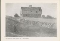
Cover and Title Page: 19th-century photograph of the now
Booklet designed by Frank A. Beard, Historian
lost Junkins Garrison, York, C. 1707
Maine Historic Preservation Commission
Contents
Introduction
try to reconstruct a century of building in Maine
which is now all but vanished.
Survivals
From the moment that European settlers first
5
There are four principal sources of information in
splashed ashore in Maine early in the 17th century,
the study of Maine's 17th-century architecture:
buildings of various sorts were constructed to
Written Records
surviving structures or parts of structures, con-
7
meet their temporary as well as long-term needs.
temporary written records, contemporary drawings,
Those settlements which flourished quickly saw
and archaeological excavation of early remains.
Pictorial Records
9
the appearance of dwellings, storehouses, barns,
In approaching the subject from these four
mills, taverns, jails, churches, smithies-in short,
directions a remarkable amount of evidence can
Archaeological Evidence
12
all of the structures which frontier villages and
be collected to piece together a picture of Maine's
towns need to function as communities.
first buildings.
Final Notes
16
For several generations, from the 1620's to 1676,
early colonial Maine thrived. And then disaster
For Further Reading
16
struck. King Philip's War raged throughout New
England as the Indians made a futile effort to
turn back the English tide. Most of Maine's
settlements were completely destroyed or badly
damaged in this conflict and, what is even worse,
King Philip's War ushered in nearly a century
of bloody strife in Maine between the English and
Illustration Credits:
the allied French and Indians. Due to this strife
and the normal ravages of time, virtually no
"The Old Garrison" by Winslow Homer courtesy
trace of Maine's 17th-century architecture survives
of Cooper-Hewitt Museum, the Smithsonian
above ground.
Institution's National Museum of Design.
This booklet is intended to be a companion to
"Piscataway River in New England" courtesy of
Frank A. Beard's 200 Years of Maine Housing:
the British Library Board.
A Guide for the House Watcher, Second Edition
(Augusta, Maine Historic Preservation Com-
Plan and Sketch, Turfrey's House, Saco Fort;
mission, 1977). Maine's architecture of the
Casco Bay Fort; and Pemaquid Barracks courtesy
settlement period is little understood, but through
of the Public Record Office, London, Crown
research more is being learned about it every
Copyright (C.O. 700, Maine 2, 11, 10.2).
year. This booklet will attempt to bridge the gap
in the study of architecture between the earliest
Spirit Pond Sod House artist's conception,
colonization of our State and the re-emergence
courtesy of Edward J. Lenik.
of prosperity in Maine in the 18th century. It will
3
4
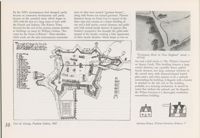
"The Old Garrison" (Junkins Garrison), York, by Winslow Homer
Survivals
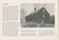
One of the most difficult problems in architectural
history is the precise dating of buildings. This
problem is particularly acute in dealing with
buildings of the 17th and early 18th centuries,
which were constructed before newspaper accounts
and other published records became common; and
long before the architect became a respected and
established professional in the eyes of society. Often
our earliest buildings can only be dated by in-
terpreting deed transfers and stylistic details.
Because of the not unnatural urge of owners to
claim the earliest dates possible, the construction
of many a building has been assigned to times
which far predate the surviving structure. And
often confusion arises when an early building is
replaced by a later one, the earlier date being
assigned to the present structure.
In this way numbers of buildings in Maine have
been attributed wrongly to the 17th century. The
McIntire Garrison in York, for example, was long
thought to have dated from 1645. It now seems
that it was built after 1707. Nevertheless, its form
derives from 17th-century architecture and it is
thus a valuable witness to its predecessors. The
house is small by later standards and consists of
McIntire Garrison, York, C. 1707
two stories with a large central chimney (rebuilt
not designed to allow settlers to pour boiling water
structures were built of hewn or sawn logs,
in 1909). Clapboard sheathing hides walls of sawn
logs which are carefully dovetailed at the corners.
onto hapless attackers huddling against the wall!
others were of frame construction. In any case
The most conspicuous feature is the overhang of
17th-century log houses must not be confused
the second story, a structural detail invented in
"Garrison" is a much misused word. In the 17th
with the log cabin famous on other American
Medieval Europe to compensate for crowded,
century the term did not refer to a specific type
frontiers of the 18th and 19th centuries. The latter
narrow streets by increasing second-floor space.
of building, but rather to houses which were
was introduced subsequently by central and
5
Contrary to popular thought, this overhang was
refuges or bases for militia. While some of these
northern Europeans.
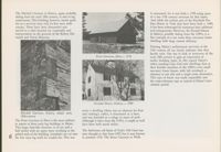
The Mitchell Garrison in Kittery, again probably
is misnamed, for it was built C. 1750 using parts
dating from the early 18th century, is also of log
of a late 17th century structure by that name.
construction. This building, however, barely quali-
And while the earliest part of the Elizabeth Per-
fies as a survivor since only its first story walls
kins House in York may have been built C. 1686,
remain. These have been dismantled and
it has been submerged by numerous later additions
moved to a safer location for reassembly and
and enlargements. However, the Fernald House
interpretation on the grounds of the Kittery His-
in Kittery, possibly dating from the 1690's, is a
torical and Naval Museum.
fine example of a one room deep, two-story frame
dwelling with large central chimney.
Viewing Maine's architectural survivals of the
17th century all too clearly indicates that they
hardly exist. One has to look at structures of the
Frost Garrison, Eliot, C. 1738
early 18th century to gain an impression of
earlier building types. In this regard Maine's
oldest standing Cape Cod style dwellings hint at
their humble ancestors of the 1600's-very small
one-story frame houses with loft overhead, a
chimney to one side and a single room downstairs.
This type of house was easily expandible into
the center-chimney cape SO typical of Maine's later
colonial period.
Fernald House, Kittery, C. 1700
never a dwelling (there was no chimney for heat
Mitchell Garrison, Kittery, detail, early
and cooking); rather, it functioned as a barn
18th-century
and was intended as a refuge in times of peril.
The Frost Garrison in Eliot is the most military
Although it dates from the 1730's, it might as well
in nature of these early log buildings in Maine.
have been built much earlier.
This large, barn-like structure is of one and a
half stories with an upper story overhang at the
The field-stone cell block of York's Old Gaol was
gabled ends of the building. Loopholes are cut into
once thought to date from 1653, but is now known
the first story log walls for musket fire. This was
to postdate 1720. The Storer Garrison in Wells
In 1633 John Winthrop of Massachusetts Bay
ordered that no man there shall build his chimney
mentioned primitive shelters on the Maine coast:
Written Records
with wood, nor cover his house with thatch.
"News of the taking of Machias by the French.
Ironically, Dudley's own house burned in 1632,
Mr. Allerton of Plimouth, and some others, had
as reported by an eye-witness, Peter Force:
"
set up a trading wigwam there
,, And again
The hearth of the Hall chimney burning all night
An early but today anonymous visitor to New
in 1643: "Mr Vines landed his goods at Machias,
upon the principal beam. River sedge and rye
England wrote that Maine "will prove a very
and there set up a small wigwam
" We can
straw were used to thatch the roofs
" Thatch
flourishing place, and be replenished with many
only imagine what an English 'wigwam' amounted
was clearly the simplest and most easily used
fair towns and cities, it being a Province both
to, since it was never precisely defined, though
roofing material for many years for all buildings.
fruitful and pleasant". This was a good prediction,
the term was used repeatedly by early eye-witnesses.
Winthrop reported that a thatched barn burned
but towns and cities take time to build, requiring
Johnson wrote of New England in general in 1642,
in Salem in 1647 (already an aged structure by
efficient saw-mills and systematic brick-making.
The Lord hath been pleased to turn all the
them, presumably) and that the new Dorchester
The first European residents of Maine and New
wigwams, huts, and hovels the English dwelt
meeting-house of 1632 was thatched. Yet by 1646
England had to improvise shelter for a few
in at their first coming into orderly, fair, and
Winthrop implied that thatched roofs were a
well-built houses."
months or longer after arrival. These earliest
thing of the past when he noted that a certain
structures nowhere survive, were never pictorially
man "took up his lodging in a poor thatched
represented, and seldom leave buried remains
Occasionally we get glimpses of construction
house".
for the historical archaeologist to identify. However,
details of the first generation of buildings. At
they are liberally mentioned in contemporary
Plymouth, Bradford mentioned in 1623 the loss of
In general these roofs were of gabled form. For
journals and letters.
a "storehouse, which was wattled up with bowes,
example, Winthrop cited an unfortunate incident
in the withered leaves whereof ye fire was kindled."
in 1636: "One Mr. Glover of Dorchester, having
Edward Johnson, writing of the first settlement
The structure's walls were made of wattle and
laid sixty pounds of gunpowder in bags to dry in
of the Boston area in 1630, noted that "The first
daub which consisted of branches plastered
the end of his chimney, it took fire and some
station they took up was at Charles Towne, where
roughly with clay or mud. Winthrop, on the other
went up the chimney; other of it filled the room
they pitched some tents of Cloath, others built
hand, in 1632 noted a house near Boston "made
and passed out at a door into another room, and
them small Huts
In 1636 the first settlers of
all of clapboards".
blew up a gable end."
Concord, west of Boston, used a different type
of shelter, according to Johnson, "They burrow
Most, if not all, of early buildings in New England
Foundations clearly were of stone, not quarried
themselves in the Earth for their first shelter
were covered with thatched roofs. We know this
granite as in the 19th century, but rocks gathered
under some Hill-side, casting the Earth aloft upon
because of the frequent reporting of fires, many
from the fields. The difficulty of building sturdy
Timber; they make a smoakey fire against the
of which were incorrectly blamed on the roofing
foundation walls with rounded New England
Earth at the highest side." William Bradford,
material (actually, wooden chimneys were the
field-stone was wryly noted by Johnson in referring
writing of the first weeks at Plymouth in 1620,
chief cause). Fires became SO common in the
to two men trying to build à church in Salem
was unfortunately far less specific: "After they
early years that Thomas Dudley wrote in 1630 to
in 1629: "One of them began to build, but when
had provided a place for their goods, or comone
Lady Bridget, Countess of Lincoln, "For the
they saw all sorts of stones would not fit in the
store
[they] begune some small cottages for
prevention whereof in our new town [Cambridge],
building, as they supposed, the one betooke him to
their habitation, as time would admit."
intended this summer to be builded, we have
the Seas againe, and the other to till the Land."
7
Cellars are mentioned fairly frequently by early
This remarkable passage, although confusing in
The tents, pit-houses, wigwams, huts, and hovels
writers. This is hardly surprising, given the
places, tells us a great deal about a first generation
which served as improvised shelter for the first
New England climate where frost-free winter
building on the Maine coast which was designed
wave of settlers were soon replaced by far better,
storage and a cool larder in the summer are
as the headquarters of a successful fishing station.
yet still primitive, thatched cottages, often with
desirable. Increase Mather at Plymouth cited an
The building, 40 by 18 feet in ground dimensions,
dangerous wooden chimneys. In due course larger
Indian in 1621 "observing in one of the English
was equipped with a single large chimney
buildings with brick chimneys appeared. By the
Houses a kind of Cellar, where some Barrels of
apparently containing two very large back-to-back
mid-17th century Johnson's description of Boston
Powder were bestowed." And Winthrop wrote of
fireplaces. A wing was evidently used for storage
suggests the rapid advance of architecture in
a Boston house in 1648 equipped with a "well
and the hand-milling of corn. At least two major
New England within barely more than a generation
in the farther end of the cellar".
rooms were serviced by the fireplaces on the first
of the first settlement: "The chiefe Edifice of
floor, a kitchen-mess hall and an office ("steward
this City-like Towne is crowded on the Sea-banks,
Most eyewitness accounts of early 17th-century
room"). Upstairs was a large dormitory, another
and wharfed out with great industry and cost,
buildings in New England concern eastern
bedroom used for storage, and a small store room.
the buildings beautifull and large, some fairly
Massachusetts (e.g., Plymouth, Boston, Salem).
This was no wigwam.
set forth with Brick, Tile, Stone and Slate
"
However, one of the best contemporary references
to a dwelling of the period comes from the pen
Building contracts often contain information of
of John Winter, agent for Robert Trelawny on
value. For example, from the Biddeford Town
Richmond's Island, off Cape Elizabeth, in 1634:
Records come these 1686 specifications for a
"I have built a house heare. that is 40 foote
framed minister's house:
"
shingled
ye
in length and 18 foot broad within the sides,
sellare dug and stoned,
ye chimbes made of
besides the Chimnay, & the Chimnay is large with
brick".
an oven in each end of him We Can brew
& bake and boyle our Cyttell [kettle] all at once
While certain generalizations about the size,
in him with the helpe of another house that
shape, and construction materials of early 17th
I have built under the side of our house, [cellar?]
century buildings in Maine and New England can
where we sett our Ceves [sieves] & mill & morter
be made on the basis of contemporary written
In to breake our Corne & malt & to dres our
records, it is well to remember that in any period
meall in, & I have 2 Chambers [upstairs bedrooms]
there is great variation from the norm. A one-
in him, and all our men lies in on[e] of them, &
story house with a central brick chimney and a
every man hath his Close borded Cabbin [bunk]:
flat roof just nine feet high is hardly typical of
and I have Rome [room] Inough to make a
early colonial architecture as we understand it.
dozen Close borded Cabbins more, yf I have need
Yet Winthrop described just that in 1646: "A
of them, & in the other Chamber I have Rome
most dreadful tempest at northeast with wind and
Inough to put the ships sail into and I have
rain, in which the lady Moodye her house at
a store house in him
& underneath I have a
Salem, being but one story in height, and a flat
Citchen for our men to eat and drink in, & a
roof with a brick chimney in the midst, had the
steward Rome
, and every one of these romes
roof taken off
"
8
ar Close with loockes & keyes vnto them."
a detailed drawing survives showing an elaborate
Pictorial Records
village within a massive fortification of irregular
star form. This drawing by a John Hunt is dated
October 8, 1607; and since it is known that the
Because virtually no 17th-century buildings survive
site of the settlement was not selected until August
in Maine and because written accounts leave
18th, many details in the drawing must be
much to the imagination, early sketches and
critically viewed. Cannon of various calibers
paintings depicting buildings of the settlement
belch smoke from most of the bastions, and the
period are extremely valuable as a source of
land and water entrances are surmounted by
information.
elaborate turreted gates of medieval form. The
buildings shown within Fort St. George (as it
The two earliest documented European attempts
was named) include a chapel with a tower at one
at colonizing the Maine coast have left us the
end, along with more than a dozen dwellings,
most dramatic graphic records of the 17th-century,
storehouses, and workshops. There is more uni-
Ironically, each enterprise failed within a year,
St. Croix Colony, 1604
formity here than at St. Croix. All the buildings
and it seems likely that the pictorial record of
are one story tall and all have gabled roofs with
each is either an exaggeration of what actually
stories; to a pair of handsome residences (R),
central or end chimneys. Yet it is hardly credible
was built, or a 'blueprint' for what was planned
consisting of attached two-story buildings with
that such a community could have been built in
but only partially completed.
central chimneys and hipped roofs. Whether
just over seven weeks.
prefabricated in France or built with local
In 1604 France established a colony on St. Croix
materials, it is known that these buildings were
While the St. Croix and Fort St. George drawings
Island (Dochet Island) off of the modern Calais.
of frame construction. Some at least were dis-
are both suspect in detail, they nevertheless give
The unfortunate combination of an exposed site,
mantled and shipped in 1605 to the new site at
a good impression of the architecture of the first
a very severe winter, starvation, and disease
Port Royal, Nova Scotia. While there is no reason
French and English settlements. And even if they
decimated the settlers, and in the following sum-
to believe that all of these buildings were not
were works of fiction, they would show, as in a
mer the colony was removed to Nova Scotia. The
constructed, Champlain's drawing almost certainly
blueprint, the intentions of the earliest colonists.
great explorer Samuel de Champlain was a
exaggerates their size and complexity. Archaeologi-
participant in the effort, and his detailed drawing
cal excavations may yet resolve the issue.
From the mid-17th century comes a map signed
of the settlement in the St. Croix River was
"I.S." of "The Piscataway River in New England".
published in 1613. This charming drawing shows
In the summer of 1607 a party of Englishmen
This depicts many individual houses dotting the
buildings and gardens at the northern end of
under the leadership of Sir John Popham estab-
coast and river banks of what are now Kittery
the island. These range in type from a kitchen
lished a settlement near the mouth of the Kennebec
and York. Practically all of the buildings shown
(I) of one story with a flat or shed type roof; to
River. The site of the Popham Colony has for
are one-story frame dwellings with central chimneys
quarters and shops for smiths and carpenters
generations been disputed, but it may lie on the
and gable roofs. Occasionally a half-story facade
(E, F) consisting of gable-roofed row-houses of
west side of the river at Atkins Bay in Phippsburg.
dormer is present along with a low gable-roofed
one and a half stories; to the residence of the
Like the St. Croix settlement, this colony was
ell. No other source SO graphically reflects how
settlement's leader, the Sieur de Monts (A), a
defeated within a year of its foundation by poor
humble were most buildings in Maine even by
small hip-roofed dwelling of one and a half
morale and a severe winter. And as with St. Croix,
about 1660.
9
By the 1690's circumstances had changed, partly
tions of what were termed "garrison houses",
because of continued development and partly
along with houses not termed garrisons. Thomas
because of the unsettled times which began in
Spinney's house on Great Cove is typical of the
1676 with the first of a long series of wars with
latter type and consists of a frame dwelling of
the French and Indians. The Kittery Town
one and a half stories, central chimney, and gable
Records for the end of the century contain sketches
roof with central facade dormer. It appears that
of buildings on maps by William Godsoe, "Sur-
Godsoe's perspective has brought the gable-ends
veyor for the Town of Kittery". These sketches,
around to the facade, creating a false appearance
while crude, are the only contemporary representa-
of three facade dormers. Much larger at two or
"Piscataway River in New England" detail, C.
1655-60
two and a half stories is "Mr. Wilson's Garrison"
on Spruce Creek. This dwelling features a large
central chimney, one (possibly three) gabled
facade dormers, two large casement windows in
the second story with diamond-shaped leaded
glass panes, and what appears to be a palisade
surrounding the building. A flagpole with a banner
is attached to the left end of the building,
probably as a warning mechanism. It should be
Occudental.
noted that without the palisade and the flagpole,
the Wilson Garrison is a thoroughly residential,
non-military building.
10
Fort St. George, Popham Colony, 1607
Spinney House, Wilson Garrison, Kittery,
In 1699 the great English military engineer, Col.
additional sleeping quarters. This was frontier
Redknap's plan and perspective drawing shows
Wolfgang W. Romer, drew precise plans of a
architecture of a basic nature. Yet it hardly differs
barracks ranged along one of the sides of the
number of existing forts on the Maine coast.
from the smallest and earliest surviving 'capes' of
curtain-wall. These were to be covered with a flat
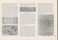
One of these was Saco Fort, built in 1693 and
the early to mid-18th century.
roof rather than the more common shed roof.
commanded by Capt. John Turfrey, among others.
Heat was to be provided by at least one pair of
Romer's plan and sketch of the installation shows
back-to-back corner fireplaces. Paired casement
Turfrey's house outside of the fort. This building
windows and doors at regular intervals were to
was of frame construction, one story high, with
give light and access to the various vaulted com-
a gabled roof. A small northern extension was
partments. While strictly military in character,
covered with a shed type roof. In plan the house
this drawing depicts living quarters which were
from south to north consisted of a major room
Casco Bay Fort, detail, 1705
planned for the Maine coast shortly after the close
and a smaller room divided by a partition and
of the 17th century.
back-to-back fireplaces. A third room beyond
Casco Bay Fort was built near the mouth of the
was unheated, as was the shed at the northern
Presumpscot River in Falmouth by Col. Romer in
end. There may have been a loft overhead for
1700 to replace Fort Loyal (located in present-
day Portland and destroyed by the French and
Indians in 1690). In 1705 Casco Bay Fort was
greatly enlarged by Col. J. Redknap, another
military engineer. Redknap's plan of the old and
new forts survives and shows the internal buildings
in plan and section. These include storehouses
and barracks. They were frame buildings with
posts set directly into the ground supported by
buried rock footings. Both gable and shed type
roofs were used.
Pemaquid was first established as a settlement
about 1625 and became England's northeastern-
most bulwark against French Acadia. As such,
it was provided with a wooden fort in 1677
(destroyed by the French and Indians in 1689)
and a stone fort in 1692 (destroyed by the same
alliance in 1696). The loss of the second fort was
a strategic blow to English Maine, and in 1699
Col Romer drew detailed plans of the lost fort
and a much larger one planned to replace it.
Plan and Sketch, Turfrey's House, Saco Fort,
In 1705 Col. Redknap did the same. Although
1699
neither of the proposed replacements was built,
Pemaquid Barracks, 1705
11
Archaeological Evidence
The fourth valuable source of information on
Maine's earliest colonial buildings is historical
archaeology. This science, through careful excava-
tion, closely analyzes the physical remains of
individual buildings or whole settlements which
have lain buried for three centuries or more.
Areas of flagstone paving, cellar holes, stone
footings, stone steps, post-holes, and certain types
of artifacts, such as hinges, latches, and window
glass, all contribute to the understanding of 17th-
century architecture in a state where practically
nothing of that period survives above ground.
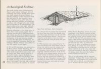
Spirit Pond Sod House, Artist's Conception
Historical archaeology is a very young science in
Maine, but it is now growing rapidly. This is
was a fire-pit. Very few artifacts were encountered,
Sabino Head in Phippsburg, because of its close
important, since the state is richer than most in
but one of them was a bowl of an English white
resemblance to the shoreline depicted on John
early colonial sites, given its low population density
clay tobacco pipe which dates from the early 17th
Hunt's plan, has been tentatively identified as the
and the relatively small amount of heavy industrial
century. Recall Edmund Johnson: "They burrow
site of Fort St. George and the Popham Colony
development. In the past generation enough
themselves in the Earth for their first shelter
of 1607. In 1962 and 1964 excavations were con-
excavation has taken place on 17th-century sites
under some Hill-side, casting the Earth aloft upon
ducted at this location with disappointing results.
to provide significant information about the lost
Timber
Although several artifacts were found which could
buildings of the first settlement period. However,
date from the early 1600's, no architectural
such field research has only begun.
In 1950 excavations were conducted by the Na-
features of the fort or its buildings were encoun-
tional Park Service on St. Croix Island. In this, an
tered. Perhaps the site has been mostly washed
In 1973 and 1974 excavations were carried out on
attempt was made to locate the footings of one
into Atkins Bay. Or perhaps the site of the exca-
the Shore of Spirit Pond in Phippsburg. The
or more of the buildings of 1604 depicted by
vations is not the site of the colony. More field
object of this work was two prominent depressions
de Champlain. Only a small area was uncovered,
survey and excavation in that part of Phippsburg
within small mounds which clearly seemed to be
suggesting substantial disturbance of the site by
will perhaps resolve the issue of the Popham
the work of man. These features turned out to
cultivation in the ensuing centuries. However, two
Colony's location once and for all.
be primitive shelters dug into the bank and
parallel stretches of field-stone footings almost
roofed over with logs and turf. The larger of the
sixty feet long may represent the foundation of a
There is no such problem with the important
two structures measured some 32 by 21 feet on
storehouse (B, in de Champlain's drawing). Other-
plantation at Pemaquid. The location of this early
the outside, enclosing an internal chamber of
wise little was found in the way of architectural
settlement was never forgotten, and much research
12
about 21 feet long by 7 feet wide, with a rock-lined
features. Clearly, more work needs to be done
and field work on this site was undertaken in
entrance. Located near the middle of the chamber
on St. Croix Island.
the last decades of the 19th century. In 1923
further excavations were conducted, but the princi-
before Indians descended on the abandoned
Many of the stone foundations at Pemaquid are
pal archaeological effort has taken place since
settlement in the first of the Indian Wars.
very small in dimensions. One, for example,
1965 and continues at this time. Besides work on
measures just 11 by 7 feet. This is not to say,
the site of Pemaquid's forts of 1677, 1692, and 1729,
Another of the village structures excavated at
however, that a frame building of that size occupied
excavations have uncovered the remains of some
Pemaquid is more residential in character and
the site. Clearly many if not most 17th-century
fourteen village structures. These remains consist
dates from the mid-17th-century. This dwelling
buildings were equipped with partial cellars, the
of clay-mortared field-stone foundations of rectan-
measures 16 by 18 feet over its stone foundation.
balance of a building covering a crawl-space. Very
gular or nearly square buildings, in most cases
At about the center of the north-west side was an
careful excavation and a trained eye must search
provided with cellars. In date these structures
entrance to the cellar. Near the east corner and
for post-holes and stains in the ground marking
range from about 1630 to the early 18th century.
built into the wall was a shallow well about 3
the positions of sleepers and sills. And rain water
feet in internal diameter which contained a wooden
falling from a roof often creates a drip-line out-
One of the earliest buildings uncovered at Pem-
barrell as a lining. Recall Winthrop's mention in
side a building's walls, indicating to the archae-
aquid consists of the stone foundation of a
1648 of a Boston house with a "well in the
ologist the extent of the roof overhang of a long-
structure roughly 40 by 24 feet with a cellar
farther end of the cellar".
vanished structure.
entrance and steps facing the harbor, as well as
flagstone flooring at another entrance on the
opposite end of the cellar.
A cache of 108 cannon balls of various calibers
B
was found in one corner of the building, and
artifacts definitely dated it to before 1676. The
foundation facing the harbor was twice the
B
thickness of the other three sides, suggesting fear of
bombardment by a water-borne enemy.
What we have here is almost certainly the remains
of "Fort Pemaquid", actually a fortified trading
post built about 1630 as a deterrent to piracy
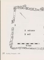
A - STEPS
(the French and Indians at this early date were
B BEDROCK
not yet a threat). The building failed in this
Remains of a fortified storehouse
PAVING
purpose, since it is known to have been rifled by
at Pemaquid, built in 1630,
the English pirate, Dixy Bull, in 1632.
attacked by pirates n 1632 and
destroyed by Indians in 1676.
10 feet
Historical records indicate that this building,
which would have been of frame construction on
stone footings, survived this raid and was de-
molished in 1676 by Pemaquid residents shortly
13
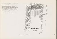
A
A entrance
B well
10 feet
14
Dwelling, Pemaquid, C. 1650
Since 1970 archaeological excavations have been
conducted on the site of the Clarke and Lake
Company on Arrowsic Island. This remarkable
industrial complex which included a fort, a trading
post, mills, foundry, and shipyard, was established
by two prominent Boston merchants in 1654. In
1676, as with other English settlements, it was
attacked and destroyed by the Indians. The in-
vestigation of this site has concentrated on one
of at least half a dozen structures.
B
Excavation of this building, while not finished,
has revealed more about the structure than
everything written about the company's physical
plant and operations. In all likelihood, it was the
trading post or headquarters. What has been
uncovered is the stone footings of a building
rectangular in plan, some 40 feet long and 15
feet wide. The northern end of the structure is
occupied by a stone chimney base and the stone-
paved hearth of an enormous fireplace which was
12 feet wide and which faced south. Traces of
sills and planks indicate that the frame building
had a wooden ground floor. A lock and key found
near the east end of the hearth suggest the position
of an entrance. Fragments of window glass were
not concentrated sufficiently to indicate fenestration,
although there was a major grouping near the
center of the east wall. Attached to the north-east
corner is a projection about 5 feet wide which runs
northward. This may represent an enclosed entrance
or an attached shed. Its northern terminus has
yet to be uncovered.
A curious feature lies to the west of the building.
This consists of what may have been a narrow
paved alley, only 2 to 3 feet wide, between the
west wall of the building and another wall farther
to the west. Future excavation should determine
the exact nature of this feature.
The tools of archaeology have only begun to be
used at the Clarke and Lake Company Site, and
even at Pemaquid much remains to be done.
Whole villages, such as Sheepscot Farms, await
excavation. In the coming decades historical archae-
ology should contribute invaluable data to the
study of Maine's 17th-century architecture.
10 feet
of
Residence, Arrowsic, 1654
15
Final Notes
For Further Reading
The Trelawny Papers, ed. by James P. Baxter
(Portland, 1884).
Winthrop, John, History of New England
Beware the Mainer who claims a home of the
SURVIVALS:
(Boston, 1825-26, 1853).
17th century. It is not so. To study the architecture
Candee, Richard M., "The Architecture of
of the state's first European settlements one must
Maine's Settlement: Vernacular Architecture to
examine early 18th-century buildings which reflect
About 1720" in Maine Forms of American
ARCHAEOLOGY:
earlier construction methods. Contemporary written
Architecture, ed. by Deborah Thompson,
Camp, Helen B., Archaeological Excavations
accounts and descriptions are invaluable. And
(Waterville, 1976).
at Pemaquid, Maine, 1965 - 1974 (Augusta,
archaeology is providing a fourth primary source
Cummings, Abbott Lowell, Architecture in
of information. Archival and field research is
1975).
Early New England (Sturbridge, Mass., re-
Hadlock, Wendell S., "Recent Excavations at
producing new data every year. As this research
vised edition, 1974).
DeMonts' Colony, St. Croix Island, Maine",
proceeds, our view of Maine's earliest buildings
Myers, Denys Peter, Maine Catalog, Historic
is becoming clearer and clearer. This is important
American Buildings Survey (Augusta, 1975),
Old-Time New England, XLIV, 4 (1954),
92-99.
if we are to understand the entire history and
1-13.
evolution of Maine's architecture, an evolution
Lane, Gardner, An Archaeological Report on
Excavations Carried out at Sabino Head in
now covering nearly four centuries.
Popham Beach, Maine, the Site of Fort St.
CONTEMPORARY ACCOUNTS:
George, 1607 - 1608 A.D. (unpublished type-
Bradford, William, History of Plimoth Plan-
script, Bureau of Parks & Recreation, Augusta,
tation (Boston, 1901).
1966).
Force, Peter, Tracts and Other Papers Relating
Leamon, James, Archaeological Report on the
Principally to the Origin, Settlement and Pro-
Clarke and Lake Settlement, Arrowsic, Maine
gress of the Colonies in North America (Wash-
for 1970 - 1975 (unpublished typescript, De-
ington, D. C., 1836-46).
partment of History, Bates College, Lewiston).
Johnson, Edward, Wonder-Working Provi-
Lenik, Edward J., The Spirit Pond Sod
dence, a History of New England, 1628
House (Milford, N. H., 1973).
1651, ed. by J. Franklin Jameson (New York,
1910).
Jones, Augustine, The Life and Work of Tho-
mas Dudley, the Second Governor of Massa-
chusetts (Boston, 1899).
Mather, Increase, A Relation of the Troubles
which have hapned in New-England, By reason
of the Indians there From the Year 1614 to the
Year 1675, ed. by Samuel Drake (Albany,
N. Y., 1864).
Maine Historic Preservation Commission Publications
This booklet is one of a continuing series of publications documenting Maine's historic,
architectural, and archaeological heritage. Sponsored by the Maine Historic Preservation
Commission, each study may be ordered free of charge on a one per person basis by
sending 50c for postage and handling to the Maine Historic Preservation Commission,
242 State Street, Augusta, Maine 04333.
Beard, Frank A., 200 Years of Maine Housing: A Guide for the House Watcher (1976).
Mundy, James H. and Shettleworth, Earle G., Jr., The Flight of the Grand Eagle: Charles
G. Bryant, Maine Architect and Adventurer (1977).
Bradley, Robert L., Maine's First Buildings: The Architecture of Settlement, 1604-
1700 (1978).

