
From collection Jesup Library Maine Vertical File

Page 1
Page 2
Page 3
Page 4
Page 5
Page 6
Page 7
Page 8
Page 9
Page 10
Page 11
Page 12
Search
results in pages
The Ancient Remains at Pemaquid, Maine: Some Observations
Jesup Memorial Library
J
34 Mount Desert St.
Bar Harbor, ME 04609-1727
THE ANCIENT REMAINS
AT PEMAQUID, MAINE
Some Observations
By Warren K. Moorehead
S
INCE very early times the ancient foundations, cellars and pavements
situated in the village of Pemaquid, Maine, have been the subject of
much discussion. Historians, as well as laymen, have written about, and
indulged in theories as to the origin of these evidences of human occu-
pation.
Most of the remains occur along a ridge or elevation, some thirty or
thirty-five feet above the inner harbor of the region now known as
Pemaquid Beach. To the northwest, directly across the narrow Pema-
quid River, have been found pavements, cellars and foundations covering
a more restricted area. On the long promontory extending to the south,
and known as Pemaquid Point, there have been discovered none of these
remains. The inner harbor is quite protected and the early inhabitants
selected this sheltered spot.
Throughout the entire distance between eastern Maine and the mouth
of the Kennebec there are few harbors more attractive than Pemaquid.
Doubtless some are larger, but Pemaquid has a setting peculiarly its
own. The tidal river forming the inner harbor is a very safe haven for
sailing vessels and small boats such as dories and canoes. When the
first voyagers came down the coast, whether Norsemen or masters of
later small sailing vessels, they would find at Pemaquid a sheltered and
convenient retreat. We must not consider Pemaquid in the light of
modern times. The large ocean craft of these days, for obvious reasons,
1
require a deeper and larger harbor. Hence, Pemaquid never developed
and its glory lies in its antiquity rather than in its present state. Indeed,
we may be quite content that Pemaquid still retains its ancient charm
and picturesqueness. The reverse is true of Portland, Bar Harbor and
other ports. All of this must be taken into consideration in a study of
Pemaquid.
It was desired during the summer of 1923 further to explore the site
of Pemaquid, partly in order to learn more of the location of pavements
and cellar holes, and partly to inquire whether the evidence uncovered
could by any chance be ascribed to a Norse source. The exploration
work was in charge of the writer, and undertaken on behalf of individ-
ual subscribers, and the Maine Historical Society. We had the advantage
of studying the reports of our predecessors, but not of seeing much of
what they uncovered. Most of what they found they destroyed, part
they buried again for protection, and a good deal was torn up for suo-
venirs by unappreciative tourists. It will be helpful to study the account
of the earliest extensive diggings.
During the year 1825 and 1826, Waterman Hatch, Esq., of Bristol,
Maine, worked at Pemaquid for Capt. John Nichols. Mr. Hatch drew up
an affidavit August 23, 1871, in which he set forth in considerable detail
his observations. He was an intelligent workman and aside from the
book Twenty Years at Pemaquid, by John H. Cartland, Esq., has left us
our best account of the remains as they existed a century ago and before
they had been disturbed to any considerable extent. It appears that
Captain Nichols desired to cultivate the entire peninsula and to that end
he employed Hatch to remove the pavements and fill the cellars.
"I, Waterman Hatch of Bristol, Maine, do make oath and say that I
am sixty-four years of age; that I have lived in Bristol all my life; that
I was at Pemaquid in the years 1825 and 1826. Worked those two years
for Capt. John Nichols who lived in the house where James Partridge
now lives.
"At that time there were cellars nearly all over the peninsula, ar-
ranged in regular rows, on several streets. There was the main street in
good repair extending from the Fort on the southern part of the penin-
sula, by the place where the barn now stands, past the graveyard and
nearly, or quite, up to the northern end of the peninsula. This street was
narrow and well paved with stones. I once ploughed over some eight
According to Mrs. Gilbert, who was his secretary, Mr. Cartland labored at Pema-
quid during twenty-four years. He spent all his money working at and near Pema-
quid and it was he who brought about action on the part of the State of Maine. He
is buried in the little cemetery back of the fort, without even a headstone.
2
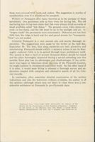
Whittingham houses
Tibbetts
S
Shell Heap
RIVER
Inner
Harbor
PEMAQUID
cc
Pemaquid
FORT
CEMETERY
Harbor
C
3
N
P
old Paving
Beach
c
Old Cellars
Pemoquid
S Indian Shell Heaps
Fish
Pt
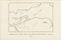
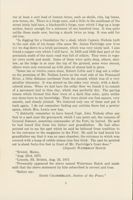
Approx Scale, 4in = Imile SKETCH - MAP OF OLD PEMAQUID FORT REGION September 1923
FIG. I
rods of this street, and abandoned the undertaking because it was too
laborious, there not being enough soil over it to make a furrow, and the
pavement being SO close and compact it was found to be impracticable
to break it up. Some parts of it were then quite bare.
"At the right angles with this were two streets extending down to the
western shore, one beginning about the middle of the graveyard fence as
it now stands and running down to the old wharf. This street was paved.
The other was about three rods north of Mr. Partridge's barn. I do not
say whether it was paved or not. There were, besides these, two streets
parallel to the main street and lying between it and the river bank, also
two at right angles with the main street running easterly from it to the
creek. I do not say they were paved. All these streets, with the excep-
tion of the one next the river bank, had cellars on both sides which were
plainly to be seen, most of them being well stoned, and deep. On the
east side of the main street there were cellars all the way from the
graveyard to the road, and east as far as the creek. I have helped to fill
up many of these. There were four cellars on the extreme northern
point of the peninsula, also large numbers south and east of the road.
I
assisted in filling up some fourteen of these which have since been
ploughed over. In the years in which I worked there the cellars were
very plainly to be seen on both sides of the main and cross streets, down
to the old wharf on the west and south as far as the barn and the main
road. East of Main Street there was a square, about six rods in extent
on each of its sides, which contained the remains of seven blacksmith
forges, four on the north side and three on the south. These forges were
built of brick and stone, were as perfect as though built yesterday. With-
in this square were large piles of cinders and other refuse such as is to
be seen about a blacksmith's shop. I ploughed out a gun-lock from one
of these heaps, which I still have. I also ploughed out a foxtrap, one foot
under ground. It had two springs, was very large, and almost destroyed
with rust. I also found an axe of very peculiar shape, to wit, triangular,
with a 'bit' six inches wide, and a round hole through it edgewise for
an eye. It was badly rusted, and I do not know what became of it. There
were quantities of nails and spikes and bushels of old iron scraps. I can
point out the sites of eleven forges in all. I should judge that on the
whole peninsula and fish-point there must have been over three hundred
cellars.
"The same year, 1825, William McIntyre and I dug up a heap of heavy
cannon shot. They were in a conical pile, entirely underground, within
the old Fort. There were forty-eight solid shot and fourteen bombshells.
Captain Nichols sold them for old iron. In ploughing between the fort
and the river, I, together with Joel Sibley and Captain Nichols, turned
4
out at least a cart load of human bones, such as skulls, ribs, leg bones,
arm bones, etc. There is a forge near, and a little to the southeast of the
street lately laid bare, a blacksmith's forge, near which I dug up a large
anchor, heavy enough for a schooner of one hundred tons. It was quite
unlike those made now, having a shank twice as long. It was sold for
old iron.
"In digging for a foundation for a shed, which Captain Nichols built
to the east side of his house (the same Mr. James Partridge now lives
in) we dug down to a brick pavement, which was very nicely laid. I also
found a copper coin which I still have. In 1825 and 1826 that part of the
peninsula south of the main road was full of cellars. They were in regu-
lar rows north and south. Some of them were quite deep, others, shal-
low, as the ledge is so near the top of the ground, some were stoned,
others were only cornered up with piles of stones laid in piers.
"Some ten or twelve years since, Robert Little and I dug out a cellar
on the premises of Mr. Nathan Lewis on the west side of the Pemaquid
River, a little distance northeast from the mound, which was of a very
peculiar character. It was stoned on the sides very nicely, with a dark-
colored stone. When we laid bare the cellar floor we found it to consist
of a pavement laid in blue clay, which was perfectly dry. The paving
stones which formed this floor were of a dark blue color, quite unlike
any stone here to my knowledge. They were about one foot square, very
smooth, and closely jointed. We removed only one of them and put it
back again. I do not remember finding any articles there but a pewter
spoon, which Mrs. Lewis now has.
"I distinctly remember to have heard Capt. John Nichols often say
that in a spot near the graveyard, which I can point out, the remains of
General Sumner, sometime commander of the Fort, lie buried. He said
he had heard this from his father and grandfather. He had often
pointed out to me the spot which he said he believed from tradition to
be the entrance to the magazine to the Fort. He said he had heard his
grandfather say that it was an open chamber, the entrance to which was
covered with a heap of cobble stones nine feet thick. The spot he pointed
out is about forty-five feet in front of Mr. Partridge's front door."
(Signed) WATERMAN HATCH
"Bristol, Maine,
"Aug. 23rd, 1871
"Lincoln, SS. Bristol, Aug. 23, 1871
"Personally appeared the above named Waterman Hatch and made
oath that the above statement by him subscribed is correct and true.
"Before me:
DAVID CHAMBERLAIN, Justice of the Peace."
5
During the course of our explorations in 1923, Cartland's book and
Hatch's affidavit were continually consulted by us.
The map accompanying this paper (Fig. I) does not show all of the
pavement and cellars described by Mr. Hatch. On the contrary, our
sketch is confined to remains actually found by us during the 1923
explorations. Additional researches undoubtedly will bring to light
more cellars and foundations and additional pavements.
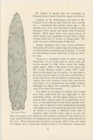
The longest stretch of pavement, called by both Cartland and Hatch,
the main street, is about 1160 feet in length. Reference to the map will
indicate that a cross street, or branch pavement, extends from the fort
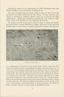
FIG. II.-Room Floor
in a southeasterly direction to the main street. South from the fort,
some six hundred feet is a rectangular pavement near the shore line. A
close view of the cobbles composing this is shown in Fig. II. The stones
composing it are smaller and more evenly laid than those forming the
main street. We determined the extent of the main pavement, or street,
by sinking many test pits. Wherever the stones appeared to be regu-
larly laid we placed on the map dots and the letter "P." Between these
letters the pavement seems to have been greatly disturbed and in places
entirely removed. The labors of Hatch and others to make of the point
farm land resulted in the destruction of much pavement, the filling of
cellars and the removal of many loads of foundation stones.
6
Not all the depressions or cellars are shown on the map, but only the
more prominent ones. A rough filed map made by me on September 15
showed some thirty cellars or depressions.
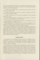
North from Pemaquid Beach, not quite a mile in a direct line, is the
property of Mrs. and Miss Whittingham. At this particular point there
are many foundation stones, some pavement and several depressions.
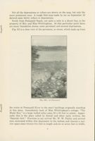
Fig. III is a close view of the pavement, or street, which leads up from
FIG. III.-A Pavement
the water at Pemaquid River to the small buildings originally standing
at this place. Immediately back of Miss Whittingham's cottage, "The
Music Box," is a large walled cellar some 35 X 20 feet in extent. Appar-
ently this is the place called by Sewall and other early writers, the
"Spanish fort." Previous to my arrival Mr. W. W. Taylor and several
men excavated within this depression to the bottom and cleared a nar-
row space some twenty-five feet in length and six or seven feet in width.
7
Hand-made nails, fragments of rusty or oxidized iron, broken china
and crockery and other objects of Colonial manufacture were found.
The entire basement or cellar, was not dug out, but it is our opinion that
enough work was done and sufficient objects recovered to prove that the
building was not of Spanish origin. The ground to the westward is high-
er and arrows could be thrown into the so-called fort. At Pemaquid
proper, where the larger fort stood, there is no high ground near. The-
oretically, it would appear that the so-called Spanish fort occupied a
very poor location for defensive purposes.
Most of the dressed stone and boulders appear to have been removed
from the Whittingham site as well as from Pemaquid proper. It is nat-
ural that fishermen and farmers seeking material for house walls or
barn foundations, would select convenient material nearest at hand. It
seems to the writer that this explains why we find little but fragmentary
foundation walls.
In the Whittingham pavement there are two distinct gutters. Both
are apparent in the picture (Fig. III). A rough diagram of the pave-
ment and the depressions on Miss Whittingham's estate was attempted,
but no accurate plan is possible unless the entire one hundred and fifty
feet area is excavated. It would appear that the central section of pave-
ment, slightly elevated, is about three feet, eight inches in width, the
gutter some ten inches wide and section beyond, to the left, about two
feet in width. The cobble stones are six to ten inches in diameter.
While part of the force investigated the pavements of excavated shell
heaps in the neighborhood and worked on Miss Whittingham's site, a
large crew began operations inside the enclosure of Fort Pemaquid.
Readers are probably familiar with the interesting history of this forti-
fication and I shall go into no details. In 1632, the pirate Dixie Bull
sacked the place. In 1689, about one-hundred Indians under the French
attacked the fort. Lieutenant Weems, who was in command surren-
dered. Some of the prisoners were killed, the others taken to Indian vil-
lags on the Kennebec. In 1692, Sir William Phips built a larger fort and
tower which was taken by the French under Iberville and Count Cas-
tine's Penobscot Indians, who came down from Pentagoet (Castine) for
that purpose. Pascho Chubb of Andover was in command at the time,
with ninety-five men. He gave up the fort, in which the Indians found
one of their prominent men chained and half dead from exposure and
abuse. Chubb was reprimanded by the General Court and put in jail at
Boston. He had previously killed some prominent Indians who had ap-
peared for the purpose of holding a meeting and on his return to And-
over, some of the Penobscot Indians came down from Maine and killed
him, together with his family.
8
The fort was rebuilt by the English in 1729. It was partially destroyed
by our forces at the time of the American Revolution. A modern stone
tower occupies a part of the old fort site and inside it is a small museum.
Our large excavations brought to light several interesting facts. The
French, English and Americans at the various times mentioned de-
stroyed the fort. Therefore, excavations down to bed rock revealed a
very disturbed condition. If the entire area were carefully dug over
and a survey plan prepared, this would not agree with either the original
French or English diagrams. The successful attacking parties recon-
structed along different lines, utilizing a part of the base walls and build-
ing others. No attempt at reconstruction was made after the final de-
molition by our forces at the time of the American Revolution. We did
not dig over the entire area, as stated, but were able to identify what
remained of the officer's quarters, the cannon emplacements, one or two
large ovens where cooking was carried on, and quarters for the men. A
hard shale, forming the bed rock, exists at depths varying from two to
five feet below the present ground level. Protection was afforded by the
walls and super-structure rather than through depth of excavation.
Little could be learned by digging out the entire space; that is, there are
short retaining walls indicating quarters almost too small to occupy. We
found fragments of swivel guns and small cannon which were appar-
ently blown up in situ; also pewter spoons, hand-made nails, fragments
of old Dutch and English clay pipes, pieces of early Dutch and English
china and glassware, small cannon balls, slugs and large bullets used in
smooth bore muskets, etc. A large gudgeon, or hinge, to the gate was
one of our most important finds. A few coins were discovered, of which
one is apparently of William the Third (1690?), although the date is
indistinct. A very large quantity of broken or disintegrated material
in glass, china, iron, porcelain and other materials was recovered from
the excavations. All these objects were placed in the local museum. At
the conclusion of the work all pits were filled.
The summer's excavation threw no new light on the possibility of
Norse settlement at Pemaquid. Such evidence as there is was previously
uncovered and may be briefly mentioned here. In the fort museum there
is a broken, unglazed jar, which was found at Pemaquid some years ago.
It is of very early make and might be of Norse origin, but we do not
claim it is such. The two bronze spear heads, described by Mr. Judd of
the Smithsonian Institution and said to have been found in the region,
may or may not be Norse. There is no direct evidence at present of
Norse occupation along the Maine coast. It would not be proper to say
that the Norse were not there. A careful reading of the rather indefinite
sagas sheds no specific light on the subject.
9
Mr. Walter B. Smith was our co-worker at
Pemaquid and I quote from his report as follows:
"Captain A. W. McFarland, who lives at Mc-
Farland Cove, told us that when he was a young
boy - something like seventy years ago - the
skeleton of a man was dug from a shell heap at
Robinson Cove (about two miles from Pemaquid
Beach). With these bones were many pieces of
metal which were supposed at that time to have
formed some sort of armor, or breast plate. We
could not learn what became of this find.
"Indian skeletons have been found elsewhere
with plates of native copper and sometimes pieces
of brass kettles accompanying the bones. It would
be interesting to know positively if this is a simi-
lar case.
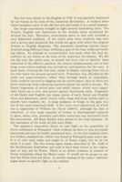
"There is a beautiful beach of white sand at
Pemaquid. It is a half mile or more long and
curves around to Fish Point where the ledges
begin again. After a big storm a few years ago
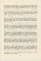
Mr. Frank McLain found a large 'flint' spear
head on the beach near this point. It was close to
the bank and he thinks it had been washed there-
from, and eleven and one-quarter inches long, two
inches wide and nowhere more than one-fourth
inch thick. It is symmetrical and boldly chipped
although its edges look somewhat battered. In
color it is a dark olive green.
"No doubt of its being an Indian relic would
have been raised but for our eagerness to find
something Norse. So this spear head as well as
certain other objects came in for particular scru-
tiny. It was noted that it was rather smooth from
wear; that it showed a faint longitudinal banding
with slight striae of weathering; that the material
of which it is made is different from that of
The Spear Head
familiar relics of this state; that it is not real
flint, but seems to be identical with certain varieties of the mineral, or
rock, called halleflinta in Scandinavian countries where such material is
not rare. These features do not prove, of course, that it was not made
by Indians and of American material, but if it is found by comparison
10
to be really identical in material and workmanship with known Scan-
dinavian relics, then there will be excuse for the following premature
surmises as to how it got here:
"a. That it was brought here by Scandinavians while they were still
living in the Stone Age.
"b. That it may have survived as an amulet or fetish even till the
time of Leif Ericson's voyage.
"C. That it drifted here in a boat, the occupants of which perhaps
perished en route.
"d. That firmly attached to a wood shaft-say of spruce-it was pos-
sible for it to have floated to our shores alone.
"These guesses are mentioned to show how far speculation may be
easily carried, with or without reason.
"This spearhead is at present in my [Mr. Smith's] possession. It
is
probably of Indian make, but should it prove to be otherwise, then it
ought to be owned and cared for by the State of Maine."
On Tuesday, September 18, 1923, the Maine Historical Society and
invited guests held a field day at Pemaquid. About 1500 people were in
attendance. Excavations were explained and speeches were made by the
State Historian, Rev. Henry S. Burrage, Dr. Alfred E. Johnson, Hon.
William D. Patterson, President C. M. Sills, Mr. Henry E. Dunnack and
others. The money for the work was raised by private subscriptions and
those who contributed were thanked by the speakers and later by the
Maine Historical Society officials.
CONCLUSIONS
It is possible, but not probable, that the armor or breastplate seen by
McFarland is Norse. The Smith spear, composed of material foreign
to Maine and common in the Scandinavian countries, might be Norse.
However, both Mr. Smith and myself feel that the evidence does not
warrant definite conclusions.
The historians have decided that Pemaquid does not mark the site of
Popham's colony, but it seems to the writer that it may be the site of a
settlement connected with some other early voyagers. The rectangular
pavement shown in Fig. II and marked on the map south of the fort,
lies about two feet below the present surface. There is a retaining wall
around it. It has been suggested that this is the floor of a house of the
Elizabethan period. It is a well-known fact that stone rather than wood-
en floors obtained in many of the houses in England in those days and
11
these were covered with reeds and rushes. The suggestion is worthy of
consideration even if it should not be accepted.
Writers on Pemaquid offer many theories as to the purpose of these
pavements. One gentleman tells us they were for drying fish. The old
sea-faring men living here claim that fish were always dried on racks or
small scaffolds called "fish flakes." The ground-even when stone-cov-
ered-is too damp, and the fish must be up in the sunlight and air. A
"wagon roads" the pavements were unnecessary. Distances are less than
1500 feet, the ridge is hard and dry and paved streets for "transporta-
tion" are not needed.
Certainly Pemaquid is a very ancient site and merits thorough ex-
ploration. The suggestions were made by the writer at the field day,
September 18. The first, that since mysteries are both attractive and
entertaining, Pemaquid should remain a mystery unless it can be thor-
oughly explored; little is to be gained through more preliminary work.
The second is that a fund of several thousand dollars should be raised
and the place thoroughly examined during a period extending over five
months. Each plan has its advantages and disadvantages. If the settle-
ment was begun by fishermen about the time of the Plymouth location,
we might hesitate to recommend additional work. On the other hand if
it is older, it would seem fitting to attempt a thorough survey and ex-
ploration coupled with complete and exhaustive search of all the Colo-
nial records.
In conclusion, after somewhat detailed examination of the surface
indications and also the historical evidence available, the author is of
the opinion-although others may not share it-that there was a con-
siderable settlement at Pemaquid in pre-Plymouth days.
Reprinted from "OLD-TIME NEW ENGLAND, the bulletin of The
Society for the Preservation of New England Antiquities." Published
by the society at the Harrison Gray Otis House, 2 Lynde Street,
Boston, Massachusetts. Vol. XIV., No. 3. January, 1924. Serial No. 35.
12

